Archipelago of Saint-Pierre Lake facts for kids
|
Native name:
Archipel du Lac Saint-Pierre
|
|
|---|---|
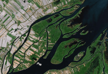
Satellite view of the Archipelago
|
|
| Geography | |
| Location | Saint Lawrence River, Lake Saint Pierre |
| Coordinates | 46°05′57″N 73°04′01″W / 46.09917°N 73.06694°W |
| Administration | |
| Province | |
| Demographics | |
| Population | 2600 (2001) |
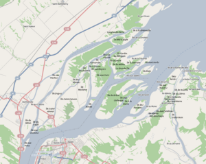
The Archipelago of Lake Saint Pierre is a group of 103 islands. You can find them in the western part of Lake Saint Pierre in Quebec, Canada. These islands are split into two main groups: the Islands of Berthier in the north and the islands of Sorel in the south.
Twenty-two villages are located along the shores of this archipelago. About 2,600 people lived on these islands in 2011. Some islands, like Dupas and Saint-Ignace-de-Loyola, have towns and houses. Most of the other islands are used for farming and raising animals.
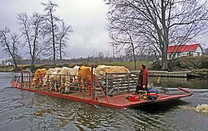
A network of small roads, many of them unpaved, connects parts of the islands. The islands of Saint-Ignace-de-Loyola, Dupas, and Castors (Beavers) are linked to the north side of the Saint Lawrence River by bridges. To get between the two sides of the Saint Lawrence River, you can use a ferry. This ferry travels between Sorel and Saint-Ignace Island, which is the biggest island in the archipelago. Most other islands can only be reached by boat. "Île des Embarras" (Embarrassment Island) on the south side is the smallest island where people live.
Contents
How the Islands Were Formed
The Archipelago of Lake Saint Pierre is a delta. This means it was formed by sediment carried by a river. It was created after the last ice age and shaped by the Saint Lawrence River. After the ice melted, the area was covered by the Champlain Sea. This sea slowly pulled back about 12,000 years ago. As it left, it deposited clayey sediments at the bottom.
The parts of the islands you can see today are made of newer soil and sand. These layers are about 7 to 8 meters (23 to 26 feet) above the river level. They were mainly deposited by the Champlain Sea. Today, something similar happens every spring. When the river floods, it covers parts of the Sorel Islands and leaves behind new layers of soil. Even though these floods can cause problems for a few weeks, they are good for farming.
Island Landscape
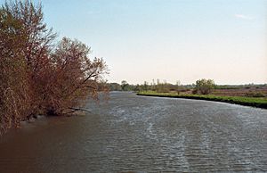
The Saint Lawrence River gets much wider as it enters Lake Saint Pierre. This is where it forms a delta with hundreds of islands and small islets. Many channels wind through these islands. The area is very flat, with not many hills. Most of the islands are only about 3 to 5 meters (10 to 16 feet) above sea level. Because of this, most islands get flooded every spring.
Weather and Climate
This region has a northern continental climate. It's a bit cooler than the Montreal area but gets much more sunshine. The period without frost is long, which is great for growing crops like cereals. Winters here are not too harsh, with some snow but not extreme cold.
Rivers and Waterways
The Archipelago area has 14 smaller rivers that flow into it. These rivers drain a huge area of 46,075 square kilometers (17,790 square miles). On average, they bring in 777 cubic meters (27,440 cubic feet) of water per second each month. There's a big difference in how much water comes from the north and south banks. The south bank, with only 4 rivers, contributes about ten times more water than the north bank.
Amazing Wildlife
The islands and Lake Saint Pierre are a very important stop for waterfowl (birds like ducks and geese) migrating in eastern Canada. These wetlands are so important for nature that UNESCO recognized their ecological value in 2000.
Island History
The first people to live on and visit the Archipelago were Native Americans. They found food and resources from the islands' wildlife. Jacques Cartier mentioned seeing the islands in September 1535. Later, on June 29, 1603, Samuel de Champlain also observed the Native Americans here.
In August 1642, a wooden fort was built. This fort was meant to protect against attacks from the Iroquois on Trois-Rivières. However, the Iroquois burned the fort down in 1647. It wasn't until 1665 that a new fort was rebuilt by Captain Pierre de Saurel's company from Carignan.
A few years later, in 1672, soldiers who had finished their service became the first settlers in the Archipelago. This is how the tradition of shared grazing land for animals on the islands began. Farming became important in this area of floodplains. By 1710, the population of the manor (a large estate) was 112 people. Most people lived on the Beaver Islands, Dupas, Saint-Ignace, and Isle Madame in the north.
In the late 1920s, several stone dams were built. These dams were placed upstream in the channels to raise the water level. This helped ships use the shipping channel south of the Archipelago.
Many summer cottages were built along the "chenal aux corbeaux" (Ravens channel). This area, between the Crows and Lapierre Islands, is famous. It was described in two French novels by Germaine Guèvremont: The Outlander (1945) and Marie-Didace (1947). The characters in these books are connected to the Sorel Islands. Germaine Guèvremont lived for almost 30 years on Îlette Pé, near the "Chenal du moyne" (Channel of the monk). Her house later became a museum for a few years.
Some of the Islands
Here is a list of some of the 103 islands in the Archipelago (listed by their French names):
- île aux Foins
- île du Mitan
- île du Sablé
- île aux Cochons
- île aux Castors
- île Dupas
- île Saint-Amour
- île Saint-Ignace
- île Ronde
- île Madame
- île aux Ours
- île de Grâce
- île aux Corbeaux
- île à la Pierre
- île des Barques
- île du Moine
- île Bibeau
- île Létourneau
- îles aux Fantômes
- île Lacroix
- île d'Embarras
- île Saint-Jean
- île Saint-Pierre
- île à la Perche
- île au Citron
- île Millette
- île de Rouche
- îles aux Raisins
- Islets Percés
- île aux Vaches
- île du Curé
- île des Plantes
- île Ducharme
- île à l'Orme
- île aux Noyers
- île Lamarche
- île à la Cavale
- île du Nord
- île du Milieu
- la Grande Île
- îles aux Sables
- île Plate
- île à Letendre
- île de la Traverse
- île Péloquin
- île Cardin
- îles de la Girodeau
- Le Nid d'Aigle
- île à la Grenouille
- îles aux Grues
 | Sharif Bey |
 | Hale Woodruff |
 | Richmond Barthé |
 | Purvis Young |


