Argonne (CDP), Wisconsin facts for kids
Quick facts for kids
Argonne, Wisconsin
|
|
|---|---|
|
Census-designated place
|
|

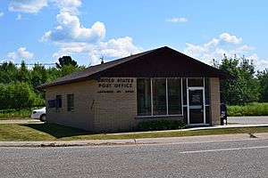
Argonne post office
|
|
| Country | United States |
| State | Wisconsin |
| County | Forest |
| Area | |
| • Total | 0.556 sq mi (1.44 km2) |
| • Land | 0.556 sq mi (1.44 km2) |
| • Water | 0 sq mi (0 km2) |
| Elevation | 1,640 ft (500 m) |
| Population
(2020)
|
|
| • Total | 135 |
| • Density | 242.8/sq mi (93.7/km2) |
| Time zone | UTC-6 (Central (CST)) |
| • Summer (DST) | UTC-5 (CDT) |
| ZIP code |
54511
|
| Area codes | 715 & 534 |
| FIPS Code | 55-02600 |
| GNIS feature ID | 1578668 |
Argonne is a small community in Forest County, Wisconsin, United States. It is known as a "census-designated place." This means it's an area defined by the government for counting people. It's not an officially incorporated town or city.
Contents
Discovering Argonne, Wisconsin
Argonne is located in the beautiful state of Wisconsin. It sits where two important roads meet: Wisconsin Highway 32 and Wisconsin Highway 55. You can find it about 6 miles (10 km) north of a town called Crandon.
A Look at Argonne's History
The community of Argonne was first established in the year 1888. Over the years, it has grown and changed. It has its own post office that serves the area. The ZIP code for Argonne is 54511.
How Many People Live Here?
Every few years, the United States counts its population. This is called a census. According to the 2020 census, 135 people lived in Argonne. This number was a little lower than in the 2010 census, when 160 people lived there.
See also
 In Spanish: Argonne (condado de Forest) para niños


