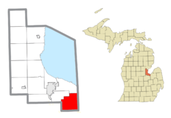
Merritt Township, Michigan facts for kids
Quick facts for kids
Merritt Township, Michigan
|
|
|---|---|

Location within Bay County
|
|
| Country | United States |
| State | Michigan |
| County | Bay |
| Established | 1871 |
| Area | |
| • Total | 31.67 sq mi (82.03 km2) |
| • Land | 31.64 sq mi (81.96 km2) |
| • Water | 0.03 sq mi (0.08 km2) |
| Elevation | 587 ft (179 m) |
| Population
(2020)
|
|
| • Total | 1,352 |
| • Density | 45.5/sq mi (17.6/km2) |
| Time zone | UTC-5 (Eastern (EST)) |
| • Summer (DST) | UTC-4 (EDT) |
| ZIP code(s) | |
| Area code(s) | 989 |
| FIPS code | 26-53220 |
| GNIS feature ID | 1626729 |
Merritt Township is a local government area in Bay County, Michigan. It is a part of the United States. In 2020, about 1,352 people lived here. Merritt Township is also part of the larger Bay City area.
Contents
Township Communities
Merritt Township has two small communities. These areas do not have their own separate local governments.
Arn Community
- Arn is a small place where the Huron and Eastern Railway meets Kinney Road and Nolet Road. It grew up around a sawmill, which is a factory that cuts logs into lumber. Arn had a post office for a while, first opening in 1877.
Munger Community
- Munger is located along Munger Road (also known as M-138). You can find it from Finn Road to west of the Huron and Eastern Railway. Munger is about 594 feet (181 meters) above sea level.
Township History
Merritt Township was officially created on July 8, 1871. Before that, it was part of Portsmouth Township. The Munger Post Office opened on June 6, 1876. A post office in Arn opened on February 28, 1877, but it closed in 1886. It reopened in 1894 and stayed open until 1904.
Township Geography
Merritt Township covers a total area of about 31.67 square miles (82.0 square kilometers). Most of this area is land. Only a very small part, about 0.03 square miles (0.08 square kilometers), is water.
Population and People
| Historical population | |||
|---|---|---|---|
| Census | Pop. | %± | |
| 1900 | 1,562 | — | |
| 1960 | 1,762 | — | |
| 1970 | 1,902 | 7.9% | |
| 1980 | 1,676 | −11.9% | |
| 1990 | 1,510 | −9.9% | |
| 2000 | 1,510 | 0.0% | |
| 2010 | 1,441 | −4.6% | |
| 2020 | 1,352 | −6.2% | |
In 2010, there were 1,441 people living in Merritt Township. There were 554 households, which are groups of people living together in one home. About 430 of these were families. The township had about 45.5 people per square mile.
Most people in the township were White (96.7%). A small number of people were from other racial backgrounds. About 2.8% of the population identified as Hispanic or Latino.
The average household had about 2.60 people, and the average family had about 2.93 people. In terms of age, about 22.4% of the population was under 18 years old. The average age of people in the township was 41.7 years.
The average income for a household in the township was $58,438. For families, the average income was $65,750. About 7.4% of all people in the township lived below the poverty line. This included 10.1% of those under 18 and 8.2% of those 65 or older.
See also
 In Spanish: Municipio de Merritt para niños


