Arrondissement of Thiers facts for kids
Quick facts for kids
Arrondissement of Thiers
|
|
|---|---|

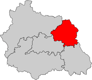
Location of Thiers in Puy-de-Dôme
|
|
| Country | France |
| Region | Auvergne-Rhône-Alpes |
| Department | Puy-de-Dôme |
| Communes | 44 |
| Subrefecture | Thiers |
| INSEE code | 635 |
| Area | |
| • Total | 865.8 km2 (334.3 sq mi) |
| Population
(2014)
|
|
| • Total | 57,956 |
| • Density | 66.939/km2 (173.372/sq mi) |
The arrondissement of Thiers is a special kind of administrative area in France. Think of it like a district or a county. It's located in the Puy-de-Dôme département (which is like a larger region) within the Auvergne-Rhône-Alpes region. The main city and capital of this arrondissement is Thiers.
Contents
History of Thiers Arrondissement
The arrondissement of Thiers was created way back in 1790. This was when the Puy-de-Dôme département was first formed. So, it has been an important part of the region for a very long time!
Geography of Thiers Arrondissement
The arrondissement of Thiers is found in the northeast part of the Puy-de-Dôme département. It shares its borders with several other areas:
- To the north, it touches the Allier département.
- To the east, it borders the Loire département.
- To the south, it's next to the arrondissement of Ambert.
- To the southwest, it's near the arrondissement of Clermont-Ferrand.
- To the west and northwest, it borders the arrondissement of Riom.
The arrondissement of Thiers is the smallest arrondissement in its département. It covers an area of 865.8 km2 (334.3 sq mi). About 57,956 people live here, which means there are about 66.9 people living in each square kilometer.
Parts of Thiers Arrondissement
An arrondissement is made up of smaller parts. Let's look at the main ones.
Cantons
Cantons are like smaller voting districts in France. After some changes, cantons can now include towns (called communes) that belong to different arrondissements.
In the arrondissement of Thiers, there are 4 main cantons:
- Lezoux
- Maringues (partly)
- Les Monts du Livradois (partly)
- Thiers
Communes
Communes are the smallest administrative areas in France, similar to towns or villages. The arrondissement of Thiers has 44 communes. Here are some of them:
- Arconsat
- Aubusson-d'Auvergne
- Augerolles
- Bort-l'Étang
- Bulhon
- Celles-sur-Durolle
- Chabreloche
- Charnat
- Châteldon
- Courpière
- Crevant-Laveine
- Culhat
- Dorat
- Escoutoux
- Joze
- Lachaux
- Lempty
- Lezoux
- Moissat
- La Monnerie-le-Montel
- Noalhat
- Néronde-sur-Dore
- Olmet
- Orléat
- Palladuc
- Paslières
- Peschadoires
- Puy-Guillaume
- Ravel
- La Renaudie
- Ris
- Sainte-Agathe
- Saint-Flour
- Saint-Jean-d'Heurs
- Saint-Rémy-sur-Durolle
- Saint-Victor-Montvianeix
- Sauviat
- Sermentizon
- Seychalles
- Thiers
- Vinzelles
- Viscomtat
- Vollore-Montagne
- Vollore-Ville
Here are the communes with the most people living in them:
| Commune | Population (2014) |
Canton |
|---|---|---|
| Thiers | 11,588 | Thiers |
| Lezoux | 5,864 | Lezoux |
| Courpière | 4,338 | Les Monts du Livradois |
| Puy-Guillaume | 2,665 | Maringues |
| Peschadoires | 2,110 | Lezoux |
| Orléat | 2,100 | Lezoux |
| La Monnerie-le-Montel | 1,786 | Thiers |
| Saint-Rémy-sur-Durolle | 1,766 | Thiers |
| Celles-sur-Durolle | 1,755 | Thiers |
| Paslières | 1,556 | Maringues |
Related pages
See also
 In Spanish: Distrito de Thiers para niños

