Arthuret facts for kids
Arthuret is a small area in Cumbria, England. It is part of the Carlisle district. In 2011, about 2,471 people lived there. The area includes the small town of Longtown and the village of Easton. The River Esk is to its west. The River Lyne is to its south.
What's in a Name?
The name Arthuret has a long history. Some people think it might be linked to a battle. This battle, called Armterid, happened around the year 573. It was written about in old Welsh records. Some scholars believe the name Arthuret might even connect to the legendary King Arthur. One idea is that it was a very important place for him. However, the exact meaning of the name is still a bit of a mystery.
King Arthur's Connections
Arthuret is very close to where the Battle of Arfderydd might have happened. This battle was fought in 573 A.D. Old writings like Vita Merlini and Annales Cambriae mention it.
The battle was between a warlord named Gwenddoleu ap Ceidio and his cousins. His cousins were Peredur and Gwrgi. They were princes from places like York or Gwynedd. Gwenddoleu lost his life in this battle.
The famous wizard Myrddin (also known as Merlin) was involved. He killed his nephew during the fight. This made Myrddin go mad. He then spent the rest of his life wandering the Forests of Celyddon. Many other important men also went mad after this battle. They later died in these woods.
An old poem from the Black Book of Carmarthen talks about Myrddin. It describes his sadness after King Gwenddolau died. The battle is said to have lasted six weeks. Three hundred men were killed and buried nearby. It was known as one of Britain's "futile battles."
Arthuret Church

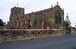
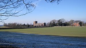
St Michael and All Angels' Church is a historic building. It is located south of Longtown. The church stands west of the A7 road. It also looks over the River Esk.
The stones of the church tower are special. Many of them have clear masons' marks. These are symbols carved by the builders. The church was built after 1607. King James I ordered money to be raised for it. The old church had often been damaged by Scottish raiders. The new church was meant to help the local people. It was also built to improve the community's morals.
There is also a holy well near the church. It is a well-built structure with a stone roof. It even has steps. People used this well for baptisms until the 1970s. The current leader of the church is Reverend Brett Murphy.
Netherby Hall
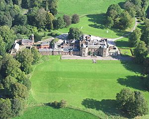
Netherby Hall is a grand old house. It has been the home of the Graham family for many years. It is a Grade II* listed building. This means it is a very important historic building.
The hall stands where an old Roman fort once was. This fort was called Castra Exploratorum. The oldest part of the hall is a pele tower from the 1400s. A pele tower was a small, strong tower. It was built to protect against attacks. The hall was made bigger in 1639 for Sir Richard Graham. It was extended again in 1833 by William Burn for Sir James Graham.
The original pele tower was likely built using stones from the Roman fort. Over time, the hall's expansions covered up the remains of the old Roman fort.
In 1592, some Scottish rebels stayed at Netherby. They played cards and football there. The Graham family has owned the Netherby Estate for 400 years. It covers a large part of the area near the Scottish border. There is also a unique building called the Coop House. It was built around 1772 to make the estate look nicer. It has now been restored.
 | May Edward Chinn |
 | Rebecca Cole |
 | Alexa Canady |
 | Dorothy Lavinia Brown |


