Arvada, Wyoming facts for kids
Quick facts for kids
Arvada, Wyoming
|
|
|---|---|

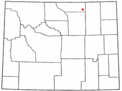
Location of Arvada, Wyoming
|
|
| Country | United States |
| State | Wyoming |
| County | Sheridan |
| Area | |
| • Total | 1.75 sq mi (4.5 km2) |
| • Land | 1.75 sq mi (4.5 km2) |
| Elevation | 3,671 ft (1,119 m) |
| Population
(2020)
|
|
| • Total | 33 |
| • Density | 18.9/sq mi (7.28/km2) |
| Time zone | UTC-7 (Mountain (MST)) |
| • Summer (DST) | UTC-6 (MDT) |
| ZIP code |
82831
|
| Area code(s) | 307 |
| FIPS code | 56-03725 |
| GNIS feature ID | 1609064 |
Arvada is a very small community in Sheridan County, Wyoming, United States. It is called a census-designated place, which means it's an area that the government counts as a community for statistics, even if it's not officially a town or city. In 2020, only 33 people lived there.
Arvada covers about 1.75 square miles (4.5 square kilometers) of land. It's a quiet place with a small population.
Climate
Arvada has a semi-arid climate. This means it's usually dry, but not a true desert. It gets some rain, but not a lot. On climate maps, this type of weather is often shown as "BSk".
History
Arvada, Wyoming, is located on the west side of the Powder River. It's about 50 miles northwest of Gillette.
From 1888 to 1891, a stagecoach line used to cross the Powder River here. Travelers used a ferry boat to get across. The town of Suggs, Wyoming, started on the east bank of the river in 1891. It even got a post office that year. Suggs was named after a local rancher.
In the summer of 1892, railroad workers built a bridge over the Powder River at Suggs. This was for the Burlington and Missouri River Railroad. Even though the railroad tracks only reached Gillette at that time, they planned for future expansion.
During a time of conflict in 1892, a group of Buffalo Soldiers arrived by train in Gillette. They marched to Suggs and built a temporary camp called "Camp Bettens." This camp was set up in mid-June 1892 and was used until mid-November.
When the railroad finally reached Suggs in 1892, officials decided to build a new town. This new town, Arvada, was planned on the west bank of the Powder River. Suggs was then left behind. The post office moved from Suggs to Arvada on July 20, 1893.
The area around Arvada has coal close to the surface. In the early days, the drinking water from local wells had natural gas mixed in. This meant the water could actually catch fire!
In 2011, the United States Postal Service suggested closing the Arvada post office. This was part of a plan to close many post offices in Wyoming.
Education
Students in Arvada go to public schools run by Sheridan County School District #3. The schools that serve the community are:
- Arvada Elementary School (for students in kindergarten through 6th grade)
- Arvada-Clearmont Junior High School (for 7th and 8th graders)
- Arvada-Clearmont High School District (for students in 9th through 12th grade)
See also
 In Spanish: Arvada (Wyoming) para niños
 | Emma Amos |
 | Edward Mitchell Bannister |
 | Larry D. Alexander |
 | Ernie Barnes |


