
Atiamuri Power Station facts for kids
Quick facts for kids Atiamuri Power Station |
|
|---|---|
 |
|
| Country | New Zealand |
| Location | Lake Atiamuri, Waikato River |
| Coordinates | 38°23′34.81″S 176°1′23.85″E / 38.3930028°S 176.0232917°E |
| Status | Operational |
| Commission date | November 1958 |
| Owner(s) | Mercury Energy |
The Atiamuri Power Station is a big building that makes electricity using water power. It's located on the Waikato River in the North Island of New Zealand. It's the third of eight power stations built along the Waikato River.
You can easily spot it from State Highway 1 when driving between Taupo and Tokoroa. Atiamuri is about 8 kilometers (5 miles) downstream from the Ohakuri Power Station. It gets its water directly from that bigger station.
Because Lake Atiamuri isn't huge, it's super important to time when Atiamuri makes electricity. This is especially true if Ohakuri is making a lot of power. Like all the Waikato River power stations, Atiamuri is run by Mercury Energy. This is a company owned by the New Zealand government.
Contents
Building the Atiamuri Power Station
Atiamuri was the fifth water-powered station built on the Waikato River. The government decided to build Atiamuri, Ohakuri, and Waipapa at the same time. Work on the dam and power station started in November 1953.
Experts from London, Sir Alexander Gibb & Partners, helped design the building parts. Most of the workers lived right at the building site in a new place called Atiamuri Village. Other workers came from Mangakino, which was the main base for building the upper Waikato River power stations.
Atiamuri Village was a real community. It had 500 homes, a movie theater, a recreation room, a cafeteria, and a library. Building Atiamuri finished six months earlier than planned. The first three machines that make electricity started working in November 1958. A fourth machine was added later and began working in April 1962.
The Atiamuri Dam
The Atiamuri Dam is made of two main parts. There's a concrete gravity dam on the north side and an earth dam on the south side.
The earth dam is 266 meters (873 feet) long and 31 meters (102 feet) high. It's 152 meters (499 feet) wide at the bottom and 7 meters (23 feet) wide at the top. This part of the dam is made from sandy clay and gravel. The side facing the water has big rocks to protect it from waves.
The concrete dam is 171 meters (561 feet) long and 44 meters (144 feet) high. It's 38 meters (125 feet) wide at the bottom and 7.3 meters (24 feet) wide at the top. This concrete part holds the big pipes (called penstocks) and the powerhouse where electricity is made. There's also a 129-meter (423-foot) long tunnel. This tunnel can let water out of the lake if needed.
In 2017, the dam was made taller. This was done to stop waves from going over the top during big storms. A new wall was built on the earth dam. Steel plates were added to the concrete dam to make it higher too.
How Electricity is Made
Water from Lake Atiamuri flows into the powerhouse through four large steel pipes. These pipes are called penstocks. Each penstock is 47.8 meters (157 feet) long and 5.5 meters (18 feet) wide.
The force of the water makes four special machines called Francis turbines spin. Each turbine spins at 126 rotations per minute. After turning the turbines, the water flows back into the Waikato River.
Each turbine is connected to a generator. Each generator makes 21 megawatts (MW) of electricity at 11,000 volts. This electricity then goes to four transformers. These transformers "step up" the voltage to 220,000 volts. This higher voltage makes it easier to send electricity over long distances.
Sending the Electricity Out
Atiamuri sends its electricity directly into Transpower's 220,000-volt power grid. The power station connects to a main power line that runs between Wairakei and Whakamaru.
From there, the electricity goes to places like Taupo and the southern Waikato region. It also travels further north to Hamilton and Auckland. Some of Atiamuri's electricity also goes to the Bay of Plenty region. This happens through another power line that connects Atiamuri to Tarukenga, which is near Rotorua.
Images for kids
-
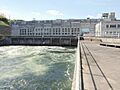
The Atiamuri Power Station on the Waikato River.
