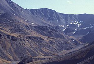
Atigun Pass facts for kids
Quick facts for kids Atigun Pass |
|
|---|---|
Composite 240-degree view of Atigun Pass
|
|
| Elevation | approx. 4700 ft. |
| Traversed by | Dalton Highway |
| Location | North Slope Borough, Alaska, United States |
| Range | Brooks Range |
| Coordinates | 68°07′46″N 149°28′33″W / 68.12944°N 149.47583°W |

Atigun Pass (AT-i-gən) is a high mountain pass in Alaska. It is about 4,739 feet (1,444 meters) high. This pass is found in the Brooks Range mountains. It sits at the start of the Dietrich River.
The Dalton Highway crosses Atigun Pass. This happens at mile marker 244. Atigun Pass is special because it is the highest pass in Alaska that stays open all year. It is also the only pass in the Brooks Range with a road crossing it.
Crossing the Continental Divide
Atigun Pass is where the Dalton Highway crosses the Continental Divide. The Continental Divide is like a big line across a continent. On one side, rivers flow to one ocean. On the other side, they flow to a different ocean. Here, water on one side of the pass flows to the Arctic Ocean. Water on the other side flows to the Pacific Ocean.
Driving the Dalton Highway
Driving through Atigun Pass can be very challenging. The pass is known for causing drivers to go off the road. During winter, there are often avalanches. These are large slides of snow and ice. Drivers need to be very careful here.
You might have seen Atigun Pass on TV. It was shown in the reality series Ice Road Truckers. This show is about the tough challenges of driving on the Dalton Highway. The pass appeared in the third and fourth seasons.
Flying Over Atigun Pass
Atigun Pass is also known among bush pilots. These pilots fly small planes in remote areas. Crossing Atigun Pass can be very difficult for them. Another pass, Anaktuvuk Pass, is often a safer flying route.
 | John T. Biggers |
 | Thomas Blackshear |
 | Mark Bradford |
 | Beverly Buchanan |


