Anaktuvuk Pass, Alaska facts for kids
Quick facts for kids
Anaktuvuk Pass
Anaqtuuvak
|
|
|---|---|

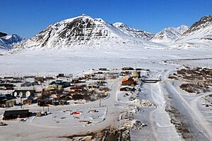
Aerial view of Anaktuvuk Pass
|
|

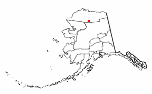
Location in Alaska
|
|
| Country | United States |
| State | Alaska |
| Borough | North Slope |
| Settled | 1949 |
| Incorporated | June 1957 |
| Area | |
| • Total | 5.23 sq mi (13.55 km2) |
| • Land | 5.18 sq mi (13.41 km2) |
| • Water | 0.05 sq mi (0.14 km2) |
| Elevation | 2,239 ft (663 m) |
| Population
(2020)
|
|
| • Total | 425 |
| • Density | 82.09/sq mi (31.70/km2) |
| Time zone | UTC−09:00 (Alaskan (AKST)) |
| • Summer (DST) | UTC−08:00 (AKDT) |
| ZIP code |
99721
|
| Area code | 907 |
| FIPS code | 02-02080 |
| GNIS feature ID | 1398235, 2419354 |
Anaktuvuk Pass is a small city in North Slope Borough, Alaska, United States. Its name comes from the Inupiaq words for "place of caribou droppings." It is the only place where the Nunamiut people, a group of Inupiat who traditionally lived inland, have settled. In 2020, about 425 people lived there.
Contents
A Look at Anaktuvuk Pass History
Anaktuvuk Pass is named after the Anaktuvuk River. The word Anaktuvuk is how "anaqtuġvik" is spelled in English. This Inupiaq word means "place of caribou droppings."
The Nunamiut People and Caribou Hunting
A group of Inupiat called the Nunamiut lived in northern Alaska. They were nomads, meaning they moved from place to place. They hunted caribou for food and supplies. This was different from other Inupiat groups who lived by the coast. Coastal Inupiat hunted marine mammals and fish. The Nunamiut traded with the coastal people for things they needed.
Around 1900 and again in the 1920s, there were fewer caribou. This made many Nunamiut move to the coast. But in 1938, some Nunamiut families returned to the Brooks Range. They settled near Tulugak and the Killik River. In 1949, this group moved to Tulugak Lake. This spot is about 15 miles north of where the village is today. Anaktuvuk Pass is the only permanent home for the Nunamiut people.
Becoming a City
This settlement brought Inupiaq people from many areas together. Today, villagers live a more settled life than when they were nomads. The city officially became a city in 1959. A Presbyterian church was built there in 1966.
The Village of Anaktuvuk Pass is a recognized tribe in the community. Most people in Anaktuvuk Pass (88.3%) are Alaska Natives or part Native. The community relies on hunting and gathering for food. Alcohol is not allowed to be sold, brought in, or owned in the village. This rule helps keep the community safe and healthy.
The Anaktuvuk Pass post office opened in May 1951. Homer Mekiana was the first postmaster. In 2009, it was thought to be the most isolated post office in the United States.
Where is Anaktuvuk Pass?
Anaktuvuk Pass is just north of the Brooks Range. It sits between the Anaktuvuk River and the John River. The city is about 2,200 feet (663 meters) high. It is the last remaining settlement of the Nunamiut Iñupiat Inuit in Alaska.
The city covers about 4.9 square miles (13.55 square kilometers). Most of this area is land. Only a small part is water.
Weather in Anaktuvuk Pass
Anaktuvuk Pass has a very cold climate. It's a subarctic climate, almost like a tundra climate. January is the coldest month, with an average temperature of about -13.4°F (-25.2°C). July is the warmest, averaging 50.3°F (10.2°C). Temperatures have been as low as -47°F (-44°C) and as high as 91°F (33°C).
The area gets about 11 inches (28 cm) of rain each year. Snowfall averages about 63 inches (160 cm). Anaktuvuk Pass is known for its strong winds and very cold winters.
| Climate data for Anaktuvuk Pass (1953–1973) | |||||||||||||
|---|---|---|---|---|---|---|---|---|---|---|---|---|---|
| Month | Jan | Feb | Mar | Apr | May | Jun | Jul | Aug | Sep | Oct | Nov | Dec | Year |
| Record high °F (°C) | 34 (1) |
29 (−2) |
37 (3) |
46 (8) |
63 (17) |
81 (27) |
91 (33) |
75 (24) |
63 (17) |
48 (9) |
37 (3) |
28 (−2) |
91 (33) |
| Mean maximum °F (°C) | 22 (−6) |
21 (−6) |
26 (−3) |
40 (4) |
58 (14) |
72 (22) |
77 (25) |
71 (22) |
57 (14) |
38 (3) |
23 (−5) |
20 (−7) |
79 (26) |
| Mean daily maximum °F (°C) | −4.0 (−20.0) |
−6.5 (−21.4) |
1.7 (−16.8) |
17.0 (−8.3) |
39.5 (4.2) |
57.1 (13.9) |
60.4 (15.8) |
53.0 (11.7) |
39.5 (4.2) |
15.1 (−9.4) |
0.3 (−17.6) |
−7.5 (−21.9) |
22.1 (−5.5) |
| Daily mean °F (°C) | −11.6 (−24.2) |
−13.4 (−25.2) |
−6.4 (−21.3) |
7.5 (−13.6) |
30.0 (−1.1) |
46.6 (8.1) |
50.3 (10.2) |
44.1 (6.7) |
32.4 (0.2) |
8.8 (−12.9) |
−7.2 (−21.8) |
−14.2 (−25.7) |
13.9 (−10.1) |
| Mean daily minimum °F (°C) | −19.2 (−28.4) |
−20.2 (−29.0) |
−14.5 (−25.8) |
−2.0 (−18.9) |
20.5 (−6.4) |
36.1 (2.3) |
40.1 (4.5) |
35.3 (1.8) |
24.7 (−4.1) |
2.7 (−16.3) |
−14.7 (−25.9) |
−21.0 (−29.4) |
5.6 (−14.7) |
| Mean minimum °F (°C) | −37 (−38) |
−40 (−40) |
−34 (−37) |
−28 (−33) |
−1 (−18) |
24 (−4) |
29 (−2) |
26 (−3) |
4 (−16) |
−16 (−27) |
−30 (−34) |
−37 (−38) |
−43 (−42) |
| Record low °F (°C) | −45 (−43) |
−47 (−44) |
−40 (−40) |
−38 (−39) |
−12 (−24) |
−11 (−24) |
8 (−13) |
14 (−10) |
−2 (−19) |
−24 (−31) |
−40 (−40) |
−45 (−43) |
−47 (−44) |
| Average precipitation inches (mm) | 0.32 (8.1) |
0.29 (7.4) |
0.51 (13) |
0.58 (15) |
0.51 (13) |
1.47 (37) |
1.77 (45) |
1.52 (39) |
1.01 (26) |
0.77 (20) |
0.49 (12) |
0.49 (12) |
9.75 (248) |
| Average snowfall inches (cm) | 6.4 (16) |
4.2 (11) |
7.5 (19) |
6.6 (17) |
2.8 (7.1) |
0.2 (0.51) |
0 (0) |
0.3 (0.76) |
6.6 (17) |
10.8 (27) |
5.8 (15) |
6.5 (17) |
57.7 (147) |
| Source: DRI | |||||||||||||
Who Lives in Anaktuvuk Pass?
| Historical population | |||
|---|---|---|---|
| Census | Pop. | %± | |
| 1950 | 66 | — | |
| 1960 | 35 | −47.0% | |
| 1970 | 99 | 182.9% | |
| 1980 | 203 | 105.1% | |
| 1990 | 259 | 27.6% | |
| 2000 | 282 | 8.9% | |
| 2010 | 324 | 14.9% | |
| 2020 | 425 | 31.2% | |
| U.S. Decennial Census | |||
Anaktuvuk Pass first appeared in the 1950 U.S. Census. It became an official city in 1957.
In 2010, there were 324 people living in the city. Most residents (81.2%) were Native American. About 7.1% were White. A small number were Black, Pacific Islander, or from two or more races.
In 2000, there were 282 people and 84 households. About 44% of households had children under 18. The average household had 3.36 people. The average family had 4.26 people.
The population was quite young. About 38.7% of people were under 18. The median age was 26 years old. The median income for a household was $52,500. For families, it was $56,250.
Jobs and Travel in Anaktuvuk Pass
It can be hard to find jobs in Anaktuvuk Pass because it is so isolated. People earn money by:
- Hunting and trapping animals for their skins.
- Guiding hunters.
- Making traditional caribou skin masks or clothing.
Some people also find seasonal jobs outside the town.
Caribou is the main source of meat for the community. Other foods include:
- trout
- grayling
- moose
- sheep
- brown bear
- ptarmigan
- water fowl (like ducks and geese)
Getting Around
The Anaktuvuk Pass Airport has a gravel runway that is 4,800 feet long. It is owned by the North Slope Borough. This airport allows planes to fly in and out all year. An airport improvement project finished in 1999. This made it easier for many airlines to offer passenger flights.
There are no roads that connect Anaktuvuk Pass to other towns. However, during winter, special vehicles called Cat trains carry cargo. They travel from the Dalton Highway, which is a road used for the Trans-Alaska pipeline. For local travel, people use Snowmobiles and all-terrain vehicles (ATVs). Some regular cars are also used.
Media and Communication
Anaktuvuk Pass has two low-power FM radio stations. K268AB (FM 101.5) plays programs from KBRW-FM. This is a public radio station in Utqiaġvik. K232DU plays programs from KYKD, a religious station from Bethel. The community also receives TV signals from the statewide Alaska Rural Communications Service on channels K04IX and K09RS.
Notable Person
- Dennis Schmitt, a well-known explorer and adventurer.
See also
 In Spanish: Anaktuvuk Pass para niños
 | James Van Der Zee |
 | Alma Thomas |
 | Ellis Wilson |
 | Margaret Taylor-Burroughs |


