John River (Alaska) facts for kids
Quick facts for kids John River |
|
|---|---|

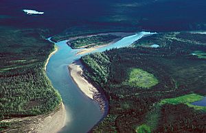
John River near Bettles
|
|
|
Location of the mouth of the John River in Alaska
|
|
| Country | United States |
| State | Alaska |
| District | North Slope Borough, Yukon–Koyukuk Census Area |
| Physical characteristics | |
| Main source | confluence of Contact and Inukpasugruk creeks Endicott Mountains, Brooks Range, North Slope Borough 2,076 ft (633 m) 68°07′34″N 151°45′23″W / 68.12611°N 151.75639°W |
| River mouth | Koyukuk River 1 mile (2 km) northeast of Bettles, Yukon–Koyukuk Census Area 600 ft (180 m) 66°54′49″N 151°39′13″W / 66.91361°N 151.65361°W |
| Length | 125 mi (201 km) |
| Type: | Wild |
| Designated: | December 2, 1980 |
- John River leads here. For Canadian rapper John River, see John River (rapper)
The John River is a river in Alaska, United States. It is about 125-mile (201 km) long. The river flows into the Koyukuk River, which is a much larger river.
The John River was named after John Bremner. He was an early explorer and prospector in the area. The river starts in the Brooks Range mountains. It flows south from a place called Anaktuvuk Pass. The river then joins the Koyukuk River near a town called Bettles. This area is just north of the Arctic Circle.
Contents
A Wild and Scenic River
A part of the John River is special. About 52-mile (84 km) of the river flows through the Gates of the Arctic National Park and Preserve. In 1980, this section was named a "wild" river. It became part of the National Wild and Scenic Rivers System.
This special name means the river is very clean. It flows freely without dams. It is also hard to reach, mostly by walking trails. This helps keep it natural and beautiful.
Wildlife and History
The valley around the John River is important for animals. It is a key path for caribou to travel. These caribou move across the Arctic lands.
Early Explorations
People have explored the John River for a long time. In 1901, two explorers named Schrader and Peters traveled the river. They continued their journey all the way to Point Barrow.
Later, in 1931, a wilderness activist named Robert "Bob" Marshall explored the river. He went up to the Arctic Divide. He wrote about seeing a "quadruple rainbow" there.
Boating Adventures
You can go boating on the John River. People use canoes, kayaks, and small rafts. But the river changes a lot along its path.
River Difficulty Levels
The first 35 miles (56 km) of the river are quite challenging. They are rated Class III on the International Scale of River Difficulty. This means they have difficult rapids. Only experienced paddlers should try this part. They also need good wilderness skills.
After this, the next 47 miles (76 km) are Class II. This means they are medium difficulty. The lowest parts of the river are Class I. These are the easiest sections.
Challenges on the River
Even though some parts are easy, there are challenges. The upper river can have fast-moving whitewater. The currents can be very strong. Sometimes, the water is too shallow for boats. There is also a difficult 4-mile (6 km) portage. A portage means you have to carry your boat over land.
 | James Van Der Zee |
 | Alma Thomas |
 | Ellis Wilson |
 | Margaret Taylor-Burroughs |


