Endicott Mountains facts for kids
Quick facts for kids Endicott Mountains |
|
|---|---|

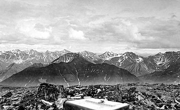
Endicott Mountains looking south, 1901
|
|
| Highest point | |
| Peak | Mount Kiev |
| Elevation | 7,775 ft (2,370 m) |
| Dimensions | |
| Length | 151 mi (243 km) East-west |
| Width | 70 mi (110 km) North-south |
| Geography | |
| Location | center of range |
| Country | United States |
| State/Province | Alaska |
| Range coordinates | 68°22′N 152°18′W / 68.367°N 152.300°W |
The Endicott Mountains are a large mountain range in northern Alaska, United States. They are a central part of the bigger Brooks Range. These mountains stretch for about 151 miles (243 km) from east to west.
To the east of the Endicott Mountains are the Philip Smith Mountains. To the west, you'll find the Schwatka Mountains. Natural features like the Middle Fork of the Koyukuk River, the Dalton Highway, and Atigun Pass help separate the Endicott Mountains from the Philip Smith Mountains. On the western side, Walker Lake and the upper parts of the West Fork of the Kobuk River (called Kaluluktok Creek) separate them from the Schwatka Mountains.
If you look at the Endicott Mountains from south to north, you'll see wide, long valleys. These valleys were shaped by ancient glaciers. Between the valleys are rounded hills. As you move towards the center of the range, the mountains become steeper. You'll find sharp, rocky peaks called tors and aretes. The northern slopes are very steep and have deep cuts and valleys. These slopes eventually lead to the flat Arctic Coastal Plain near the Arctic Ocean.
Tall Peaks and Rocky Spires
The Endicott Mountains are home to many impressive peaks. Some of these include the famous Arrigetch Peaks, known for their dramatic, jagged shapes. Here are some of the highest peaks in the range, listed from tallest to shortest:
- Mount Kiev at 7,775 feet (2,370 m)
- Thibedeau Mountain at 7,539 feet (2,298 m)
- Mount Doonerak at 7,457 feet (2,273 m)
- Cockedhat Mountain at 7,410 feet (2,259 m)
- Caliban at 7,181 feet (2,189 m)
- Xanadu at 7,160 feet (2,182 m)
- Fan Mountain at 7,090 feet (2,161 m)
- Dan Peak at 7,055 feet (2,150 m)
- Wichmann Tower at 6,916 feet (2,108 m)
- Mount MacVicar at 6,693 feet (2,040 m)
- Ariel Peak at 6,685 feet (2,038 m)
- Boreal Mountain at 6,654 feet (2,028 m)
- Mount Arthur Emmons at 6,556 feet (1,998 m)
- Rumbling Mountain at 6,510 feet (1,984 m)
- Iniakuk Peak at 6,490 feet (1,978 m)
- Mount Stuver at 6,286 feet (1,916 m)
- Mayukuit Mountain at 6,240 feet (1,902 m)
- Sillyasheen Mountain at 6,188 feet (1,886 m)
- Bluecloud Mountain at 5,903 feet (1,799 m)
- Gray Mountain at 5,783 feet (1,763 m)
- Sirr Mountain at 5,712 feet (1,741 m)
- Frigid Crags at 5,501 feet (1,677 m)
- Plateau Mountain at 5,322 feet (1,622 m)
- Natat Mountain at 5,141 feet (1,567 m)
There are also many other unnamed peaks that rise over 7,000 feet (2,134 meters) tall.
How the Mountains Were Formed
The rocks that make up the Endicott Mountains tell a long story about Earth's history. Deep below the surface, there's a base layer of very old, hard rock. This is called the crystalline basement.
Above this ancient base, you'll find layers of sediment that formed a very long time ago. These sediments were laid down during the Precambrian and Paleozoic eras. Over millions of years, these layers underwent metamorphosis. This means they changed due to heat and pressure, turning into different types of rock.
One important rock layer is the Kanayuk Conglomerate. This rock formed from sediments carried by a large river and deposited on its flood plain. It's incredibly thick, sometimes up to 8,000 feet (2,400 m). Scientists believe this huge river system created a massive delta, like a fan-shaped landform, that was almost 500 miles (800 km) long and 30 miles (48 km) wide. This process of deposition began in the Devonian period and continued into the Mississippian period.
 | Dorothy Vaughan |
 | Charles Henry Turner |
 | Hildrus Poindexter |
 | Henry Cecil McBay |

