Arrigetch Peaks facts for kids
Quick facts for kids Arrigetch Peaks |
|
|---|---|
 |
|
| Dimensions | |
| Area | 103.42 km2 (39.93 sq mi) |
| Geography | |
| Country | United States |
| State | Alaska |
| Range coordinates | 67°25′N 154°11′W / 67.417°N 154.183°W |
| Arrigetch Peaks National Natural Landmark | |
|
IUCN Category III (Natural Monument)
|
|
| Established | 1968 |
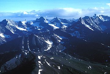
The Arrigetch Peaks are a group of tall, rocky mountains in northern Alaska. They are part of the Endicott Mountains in the central Brooks Range. The name Arrigetch comes from the Inupiat people. It means 'fingers of the outstretched hand'. This name fits well because the peaks look like giant fingers reaching up to the sky.
These peaks are found near the start of the Kobuk River. They are also close to two streams that flow into the Alatna River. These streams are called Arrigetch Creek and Aiyagomahala Creek. All the main peaks are about 6,000 feet (1,825 meters) high. In 1968, the Arrigetch Peaks area became a National Natural Landmark. This was because of its amazing and unique geography.
Exploring the Arrigetch Peaks
People have been exploring the Arrigetch Peaks for a long time. The first official study of the area was in 1911. It was done by Philip S. Smith and H.M. Eakin.
Famous Explorers
A well-known person who loved nature, Robert Marshall, explored these peaks in the 1930s. He wrote about his trips in two books. One was called Arctic Village (1933). The other was Alaska Wilderness: Exploring the Central Brooks Range, which came out after he passed away.
First Climbs
The Arrigetch Peaks are very challenging to climb. The first successful rock climbing trip happened in 1964. An American team led by Brownell Bergen made this important climb. Since then, many other climbing groups have visited the peaks. They come to test their skills against these tough granite mountains.
 | Madam C. J. Walker |
 | Janet Emerson Bashen |
 | Annie Turnbo Malone |
 | Maggie L. Walker |


