
Australind, Western Australia facts for kids
Quick facts for kids AustralindWestern Australia |
|||||||||||||||
|---|---|---|---|---|---|---|---|---|---|---|---|---|---|---|---|
 |
|||||||||||||||

Australind
Location in Western Australia
|
|||||||||||||||
| Established | 1841 | ||||||||||||||
| Postcode(s) | 6233 | ||||||||||||||
| Area | [convert: needs a number] | ||||||||||||||
| Location | 12 km (7 mi) from Bunbury | ||||||||||||||
| LGA(s) | Shire of Harvey | ||||||||||||||
| State electorate(s) | Murray-Wellington | ||||||||||||||
| Federal Division(s) | Forrest | ||||||||||||||
|
|||||||||||||||
Australind is a town in Western Australia. It is located about 12 kilometers (7.5 miles) north-east of Bunbury's main city area. The local government area for Australind is the Shire of Harvey. In 2016, Australind had a population of 14,539 people.
Contents
History of Australind
Early Days and European Arrival
Before Europeans settled here, the land belonged to the Wardandi people. These Aboriginal people were known for their excellent tracking skills. Many of them later worked on farms in the area.
The first time Europeans saw this coast was in 1658. Captain A. P. Jonk of the Dutch East India Company ship Emeloort spotted land. A few months later, another Dutch ship, Elburg, anchored near what is now Bunbury. Its captain, J. P. Peereboom, met three Aboriginal people.
In 1802–1803, a French explorer named Nicolas Baudin visited the coast. He explored the nearby rivers and the estuary. He named Point Casuarina in Bunbury and the Leschenault Inlet. The inlet was named after Jean Baptiste Leschenault de la Tour, a botanist on Baudin's ship.
Founding the Settlement


The name Australind combines "Australia" and "India." People believed the area would be good for breeding horses for the British Indian Army. This idea was later tried in other places like Cervantes.
In 1840, a group called the Western Australian Land Company bought a large area of land. They planned to build an English-style village there. The area had been explored and mapped earlier. The company had a detailed plan for the town. It included a town square, a church, a school, shops, a mill, and a public hall.
Marshall Waller Clifton arrived in 1841 and became the leader of the 440 settlers. However, not long after, a Methodist minister warned people not to move to Australind. He said it was not a good place for new settlers.
Challenges and Decline
The settlement soon faced problems. The soil was poor, and the climate was difficult. There was not enough water in summer and too much in winter. Because of these issues, many settlers left. Most of the planned town was never built. The company eventually closed down. The land was returned to the government, and the settlement plans were officially stopped in 1875.
Despite these problems, Australind continued to exist. A bridge was built over the Brunswick River. This helped nearby farmers use the town's services. By the 1860s, Australind had a school, a post office, and a store. However, it did not grow much.
In the 1890s, a railway was built from Perth to Bunbury. This shifted development to other towns further inland. Australind's population dropped to just 33 people in 1898. By 1971, 418 people lived in the area.
Modern Growth and Landmarks
The name "Parkfield" lives on in a nearby area and a primary school. A few old buildings from the early days still stand. These include St Nicholas Church (built in 1848) and Henton Cottage (built in 1841). St Nicholas Church is believed to be the smallest church in Australia. Henton Cottage was the town's first hotel. Clifton's old home, Upton House (built in 1847), is also still there.
In the 20th century, Australind became more popular for homes and recreation. As Bunbury grew into a city, Australind also expanded. The Bunbury Golf Course was built in 1948. Factories, like a titanium dioxide plant, were also built. By 1981, Australind had quadrupled in size.
A primary school opened in 1980, and a high school opened in 1987. New housing areas were developed. By 2001, Australind was mainly a residential town. The census showed over 10,000 residents. Many of them were British immigrants, and there was also a notable Italian community.
Geography of Australind

Australind is located between several natural features. The Collie River is to its south. The Leschenault Estuary is to its west. The Brunswick River is to its east. The town includes areas like Galway Green and Clifton Park. Some nearby suburbs, like Leschenault and Kemerton, used to be part of Australind.
An early description of the area noted its beautiful location. It sits on the eastern side of Leschenault Inlet. This area was considered a good place for ships to anchor, even during strong winds.
Facilities in Australind
Australind has several shopping centers for its residents. The Australind Village Shopping Centre has a Coles supermarket and other specialty stores. Treendale, another area in Australind, has the Treendale Shopping Centre. This center includes a Woolworths supermarket that opened in 2012. A 24/7 Spudshed supermarket also opened in 2016.
For sports and recreation, the 18-hole Bunbury Golf Club is located in Australind. It hosts the annual South West Open golf tournament every June.
Education in Australind
Australind has two high schools:
- Australind Senior High School
- Our Lady of Mercy College
There are also six primary schools:
- Australind Primary School (opened 1980)
- Treendale Primary School (opened 2014)
- Clifton Park Primary School (opened 1988)
- Parkfield Primary School (opened 1993)
- Kingston Primary School (opened 2009)
- Leschenault Catholic Primary School
Transport in Australind
Australind has a bus service, route 841, that connects it to Bunbury's main bus station. The bus ride takes about 32 minutes. This service is run by TransBunbury for the Public Transport Authority.
Even though there is a train service called the Transwa Australind, it does not stop in Australind itself. It also does not travel through the town.
Images for kids
-
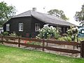
Henton Cottage, opposite the Australind Village Shopping Centre
-
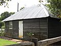
The Historic St Nicholas Church building. This sits in front of the new and much larger modern building where the current church gather throughout the week


See Also
- Bunbury, Western Australia
- Shire of Harvey
