Axis occupation of Serbia facts for kids
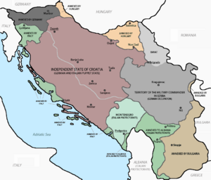
During World War II, from 1941 to 1944, parts of what is now Serbia were taken over by the Axis Powers. Most of this area was controlled by the German army, called the Wehrmacht. They set up a special area known as the German Military Administration in Serbia.
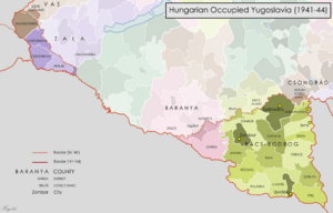
Other parts of modern Serbia were taken by different Axis countries. For example, Syrmia was taken by the Independent State of Croatia. Bačka was taken by Hungary. Southeastern Serbia was taken by Bulgaria. Southwestern Serbia was taken by Italy. These parts became part of Italian-controlled Albania and Montenegro.
Contents
German Control in Serbia During World War II
The area under German control was first occupied by German soldiers. Later, Bulgarian troops mostly took over, but the Germans still had the main power. This area was officially called the Territory of the Military Commander in Serbia.
This territory had two Serbian "puppet governments." These were local governments controlled by the German military. The first one was called the Commissioner Government, led by Milan Aćimović. The second was the Government of National Salvation, led by Milan Nedić.
During this time, the Germans created a popular radio station called Soldatensender Belgrad. It broadcasted to German soldiers across Europe and Africa. Sadly, many Jewish people living in these areas, about 11,000, were killed.
Italian and Albanian Control in Serbia
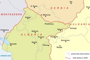
There was a disagreement between Germany and Italy over the border in the Kosovo region. This was because of important lead and zinc mines at Trepča. Also, a key railway line from Kosovska Mitrovica to Skopje was in this area.
In the end, Germany got control of the most important parts. The border, called the "Vienna Line," went from Novi Pazar in the Sandžak region. It then went through Kosovska Mitrovica and Pristina. It followed the railway between Pristina and Uroševac.
The districts of Kosovska Mitrovica, Vučitrn, and Lab were all part of the German-controlled area. This area also had other important mines. These included the lead mine at Belo Brdo and a magnesite mine at Dubovac.
The Sandžak region was first split between German and Italian control. The border changed a few times in 1941. It finally settled along the general line of Priboj–Nova Varoš–Sjenica–Novi Pazar. However, towns like Priboj and Nova Varoš were on the Italian side. The government of the Independent State of Croatia wanted to take over the Sandžak. They thought it would be easier if the Germans controlled more of the area.
Hungarian Control in Serbia
Adolf Hitler decided how the Bačka and Banat regions would be divided. The river Tisa became the border. The area east of the Tisa stayed under German control, along with "Old Serbia." The area west of the Tisa was taken by Hungary.
The Banat region was important to Germany for a few reasons. It had about 120,000 ethnic Germans, called Volksdeutsche. It was also a valuable economic area. Besides the Tisa, the Banat's borders were the Danube to the south. The other borders were the Yugoslav-Romanian and Yugoslav-Hungarian borders from after World War I.
Croatian Control in Serbia
Much of the western border between German-controlled Serbia and the Independent State of Croatia (NDH) was set in June 1941. The border followed the Drina river down to Bajina Bašta. The rest of the border was decided later in July 1941. It continued to follow the Drina river.
An area in eastern Syrmia was first included in German-controlled Serbia. This was for military and economic reasons. Belgrade's airport and radio station were there. Also, many Volksdeutsche lived there, and the area provided food for Belgrade. The border ran between Slankamen on the Danube and Boljevci on the Sava river.
However, the NDH government wanted this area. With support from the German ambassador in Zagreb, Siegfried Kasche, it was given to the NDH. This happened on October 10, 1941. The local Volksdeutsche asked for the area to be returned to German control, but it wasn't. Because of this change, the borders of the NDH reached close to Belgrade.
Bulgarian Control in Serbia
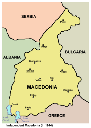
Some parts of Serbia, including Vranje, Bosilegrad, Caribrod, and Pirot, were taken by Bulgaria.
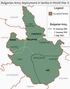
In January 1942, the Germans started using Bulgarian troops in large areas of Serbia. This was to protect railroads, highways, and other important structures. These Bulgarian troops were still under German command. This happened in three steps. The Bulgarian 1st Occupation Corps, with three divisions, moved into Serbia on December 31, 1941.
This corps was in charge of about 40% of the territory. This included large parts of the Belgrade–Niš–Sofia railway lines. They also controlled the main Belgrade–Niš–Skopje highway.
In January 1943, the Bulgarian area grew bigger. It included all areas west of the Ibar river. This allowed the 7th SS Volunteer Mountain Division Prinz Eugen to move to the NDH. They went there to fight against the Partisans. Many Volksdeutsche from Serbia served in this division. Sadly, this division was involved in terrible actions against people in Bosnia and Herzegovina.
In July 1943, the Bulgarian control zone expanded even more to the north. A fourth division, the 25th Division, took over more territory. From this point, German forces only directly controlled the area around Belgrade. They also controlled the northwest region bordering the NDH, and the Banat.
 | Dorothy Vaughan |
 | Charles Henry Turner |
 | Hildrus Poindexter |
 | Henry Cecil McBay |


