
Bačka facts for kids

Bačka (Serbian Cyrillic: Бачка) or Bácska is a flat, fertile area in Central Europe. It's like a big, open field bordered by the Danube River to the west and south, and the Tisza River to the east. This region is split between two countries: Serbia and Hungary. Most of Bačka is in Serbia, within a region called Vojvodina. Novi Sad, the capital of Vojvodina, is right on the edge of Bačka. A smaller part of Bačka is in northern Hungary, in a county called Bács-Kiskun.
Contents
What's in a Name? Bačka's Meaning
The name "Bačka" has an interesting history. Serbian historians believe it comes from "Bač," an old town in the region. The ending "-ka" means "the land that belongs to Bač."
The town name "Bač" itself is a bit of a mystery. It was known by different groups like the Vlachs, Slavs, and Hungarians in the Middle Ages. Its origin could be from ancient Balkan languages, Romanian, Slavic, or even Old Turkic.
Hungarian historians suggest the name might come from the first leader of Bač castle. They think it might be from an Old Turkic word "baya," which was a title of importance.
In the 17th and 18th centuries, many Serbs lived in Bačka. Because of this, Hungarians sometimes called it "Raczorszag," which means "the Serb country."
Bačka's Long History Journey
Bačka has been part of many different empires and kingdoms throughout time. Imagine a place that has seen so many changes! It was once part of ancient Dacia, then the Hun Empire, and later the Avar Khanate.
Slavic people settled in Bačka in the 6th and 7th centuries. In the 9th century, it was part of the First Bulgarian Empire. A Bulgarian duke named Salan ruled here, and his main city was Titel. In the early 10th century, Hungarians took control of the area.
Medieval Times and Fortresses
Around the year 1000, during the time of Stephen I of Hungary, two counties were formed in Bačka: Bács County and Bodrog County. They later joined to become Bács-Bodrog County. The town of Bač became very important. In 1085, it became the center of a major church area.

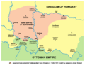
The Bač Fortress was built in the 14th century by King Charles I of Hungary. It became a key defense point against the Ottoman Empire. The Franciscan monastery in Bač is the oldest church building in present-day Vojvodina.
Ottoman Rule and New Settlers
In 1526, the Ottoman Empire defeated the Kingdom of Hungary. After this, Bačka became a short-lived Serbian state led by Emperor Jovan Nenad. His capital was Subotica. But this state didn't last long, and Bačka soon became part of the Ottoman Empire.
During Ottoman rule, many Hungarian people left the area. Serbs and other South Slavs from the Balkans moved in. This changed who lived in the region a lot. Bačka became mostly populated by Serbs and Muslims.

In 1697, a very important battle happened near Senta in eastern Bačka. The Christian forces, led by Prince Eugene of Savoy, defeated the Ottoman army. This victory led to the Treaty of Karlowitz in 1699, which ended Ottoman control in much of Central Europe. Bačka then became part of the Habsburg monarchy.
Habsburg Era and Changes
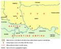
Under Habsburg rule, parts of Bačka became a "Military Frontier." This was a special area where soldiers, mostly Serbs, lived and guarded the border against the Ottomans. This system helped the Habsburgs control the region.
In the 18th century, the Habsburgs encouraged many new people to settle in Bačka. This was because the population was low after the wars. Serbs from the Ottoman Balkans, Hungarians returning to Bačka, and Germans (called Donauschwaben or Danube Swabians) moved here. Slovaks and Rusyns also settled, but in smaller numbers.
19th and 20th Century Changes
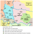
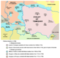
In 1848, a Serb uprising happened during the Hungarian Revolution of 1848. Bačka was declared part of a Serbian autonomous region. Later, between 1849 and 1860, it was part of a separate Austrian territory called the Voivodeship of Serbia and Banat of Temeschwar.
By 1910, the population of Bačka was a mix of Hungarians, South Slavs (like Serbs), and Germans.
After World War I, in 1918, the region of Banat, Bačka, and Baranja decided to unite with the Kingdom of Serbia. This led to the creation of the Kingdom of Serbs, Croats, and Slovenes (later called Kingdom of Yugoslavia). The Treaty of Trianon in 1920 officially divided Bačka between Hungary and the new Kingdom.
World War II and Beyond
In 1941, during World War II, the Yugoslav part of Bačka was taken over by Hungary. During this time, many people suffered. After the war, in 1944, Bačka became part of the new Socialist Federal Republic of Yugoslavia. Most of the German population left the area.
Since 1945, the Yugoslav part of Bačka has been part of the Autonomous Province of Vojvodina. After Yugoslavia broke up, it became part of Serbia and Montenegro in 2003, and then an independent Republic of Serbia in 2006.
Bačka's Geography and Rivers

Bačka is a very flat and fertile area. It's part of the larger Pannonian Plain, which was once an ancient sea! The Danube River forms its western and southern borders, and the Tisza River forms its eastern border. These two rivers meet near Titel. The region also has a network of canals called the Danube–Tisa–Danube Canal system, which helps with farming and transportation.
Most of Bačka is in Serbia, and a smaller part is in Hungary. There are even tiny, uninhabited parts on the Danube's left bank that are technically part of Croatia, but Serbia controls them.
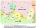
Serbian Bačka: Districts and Cities

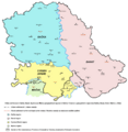
The Serbian part of Bačka is divided into three main districts:
- West Bačka
- North Bačka
- South Bačka
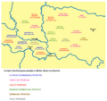
Novi Sad, the capital of Vojvodina, is the biggest city in the Serbian part of Bačka. It sits on both sides of the Danube River, right where Bačka meets another region called Syrmia.
Here are some of the larger cities and towns in Serbian Bačka (with their 2011 populations):
- Novi Sad (250,439 people)
- Subotica (97,910 people)
- Sombor (47,623 people)
- Bačka Palanka (28,239 people)
- Vrbas (24,112 people)
- Bečej (23,895 people)
- Temerin (19,661 people)
- Senta (18,704 people)
Hungarian Bácska: Counties and Towns

The Hungarian part of Bačka is mostly in the Bács-Kiskun county. A small piece is in the Baranya county.
The most important town in Hungarian Bácska is Baja, with about 38,143 people. Other towns include Jánoshalma (9,866 people) and Bácsalmás (7,694 people).
Who Lives in Bačka? Demographics

In Serbia
According to the 2022 census, the Serbian part of Bačka has about 924,879 people. The main groups are:
- Serbs (about 66.88%)
- Hungarians (about 15.31%)
Most people speak Serbian (81.74%), followed by Hungarian (14.78%). There are also Slovaks, Croats, Bunjevci, Rusyns, Montenegrins, Romani, and Germans.
In Hungary
The Hungarian part of Bačka has about 113,432 people (2001 census). Most of the people living here are ethnic Hungarians.
Gallery
-
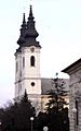
Srbobran
-
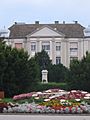
Baja
-
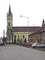
Kanjiža
-
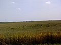
Wheat field near Temerin


Images for kids
-
Ancient Proto-Indo-European peoples in Bačka
-
Slavs in Bačka in the 6th century
-
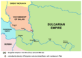
Voivodeship (Duchy) of Bulgarian duke Salan, 9th century
-
Bach and Bodrogh counties in the 14th century
-
Serbian empire of Jovan Nenad, 1526–1527
-
Bačka as part of the Ottoman Sanjak of Segedin in 1568–1571
-
Military Frontier in Bačka in 1699
-
District of Potisje and Schajkasch Battalion, 18th-19th century
-
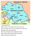
Bačka within the proclaimed borders of Serbian Voivodship in 1848
-
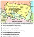
Voivodeship of Serbia and Banat of Temeschwar (1849-1860)
-
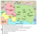
Banat, Bačka and Syrmia after 1881, the five counties, which were formed in the territory of the former Voivodeship of Serbia and Banat of Temeschwar
-
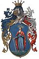
Coat of arms of Bács-Bodrog County
-
Kingdom of Hungary in 1490. Bács County - marked 31, Bodrog County - 32, Csongrád County - 23.
-
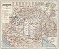
Detailed map of Bács-Bodrog County
-
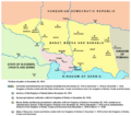
Banat, Bačka and Baranja in 1918
-
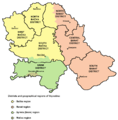
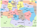
Districts in Vojvodina
-
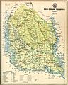
Map showing cities and towns in Serbian part of Bačka.


.png)


See also
 In Spanish: Bačka para niños
- Bačka Oblast
- Bács-Bodrog
- Bács-Kiskun
- Banat, Bačka and Baranja
- Eparchy of Bačka
- FK Bačka Bačka Palanka
- North Bačka District
- South Bačka District
- Vojvodina
- West Bačka District
