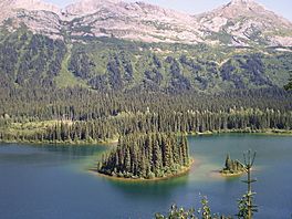
Azouzetta Lake facts for kids
Quick facts for kids Azouzetta Lake |
|
|---|---|
 |
|
| Location | British Columbia |
| Coordinates | 55°23′16″N 122°36′49″W / 55.38778°N 122.61361°W |
| Type | Lake |
| Part of | Peace River Watershed |
| Primary outflows | Atunatche Creek |
| Surface area | 1.37 km2 (0.53 sq mi) |
| Max. depth | 25 m (82 ft) |
| Water volume | 18,452,861 m3 (651,656,600 cu ft) |
| Shore length1 | 8,220 m (26,970 ft) |
| Surface elevation | 876 m (2,874 ft) |
| Islands | 5 |
| 1 Shore length is not a well-defined measure. | |
Azouzetta Lake is a beautiful lake located in the Hart Ranges of the Northern Rockies. This stunning natural spot is found in British Columbia, Canada. It sits at an elevation of 876 meters (about 2,874 feet) above sea level.
The lake is right next to Pine Le Moray Provincial Park. This makes it a great place to visit if you love nature and outdoor activities.
Contents
Discovering Azouzetta Lake's History
Azouzetta Lake has had a few different names over the years. When people first explored this area, they called it by various names.
How the Lake's Name Changed
In the 1870s and 1880s, it was often known as Summit Lake. Later, around 1907, it was sometimes called Pollen Lake. Finally, by 1917, the name Azzouzetta (Summit Lake) started to be used. This shows how places can get new names as maps and records change over time.
Exploring the Lake and Its Surroundings
Azouzetta Lake is part of the larger Peace River Watershed. This means its waters eventually flow into the Peace River. The lake itself is quite large, covering an area of about 1.37 square kilometers (0.53 square miles).
What Makes Azouzetta Lake Special?
The lake is fairly deep, reaching a maximum depth of 25 meters (about 82 feet). It also has five small islands, adding to its scenic beauty. The shoreline stretches for about 8,220 meters (over 27,000 feet). This makes it a great spot for exploring or just enjoying the peaceful views of the Northern Rockies.
 | Leon Lynch |
 | Milton P. Webster |
 | Ferdinand Smith |


