Bahía Honda, Cuba facts for kids
Quick facts for kids
Bahía Honda
|
|
|---|---|

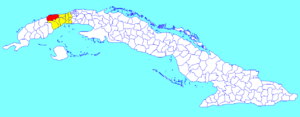
Bahía Honda municipality (red) within
Artemisa Province (yellow) and Cuba |
|
| Country | Cuba |
| Province | Artemisa |
| Area | |
| • Total | 784 km2 (303 sq mi) |
| Elevation | 25 m (82 ft) |
| Population
(2022)
|
|
| • Total | 42,522 |
| • Density | 54.24/km2 (140.47/sq mi) |
| Time zone | UTC-5 (EST) |
| Area code(s) | +53-82 |
| Climate | Af |
Bahía Honda is a town and a special area called a municipality in Cuba. It is part of the Artemisa Province. Before 2011, it was in the Pinar del Río Province.
About Bahía Honda
Bahía Honda is located on the northern coast of Cuba. It sits in a small bay that opens into the Florida Straits. This bay is about 70 kilometers (43 miles) west of Havana, Cuba's capital city.
The name "Bahía Honda" means "Deep Bay" in Spanish. This deep, sheltered bay is home to an important industrial port. It also marks the eastern edge of a group of small islands called the Colorados Archipelago.
Historical Importance
Long ago, Bahía Honda was one of the places the United States used as a naval base. This was part of an agreement called the Platt Amendment. However, in 1912, the U.S. gave up this base. In return, they got more land around Guantánamo Bay for their naval base there.
People and Land
In 2022, about 42,522 people lived in the Bahía Honda municipality. The total area of Bahía Honda is 784 square kilometers (303 square miles). This means there are about 54 people living in each square kilometer.
Climate in Bahía Honda
Bahía Honda has a tropical rainforest climate. This type of climate is often called "Af" on climate maps. Even though some areas nearby have a dry season, Bahía Honda gets plenty of rain all year. The driest month, March, still receives at least 68 millimeters (2.7 inches) of rain. This makes it a very humid place.
See also
 In Spanish: Bahía Honda (municipio) para niños
 | Anna J. Cooper |
 | Mary McLeod Bethune |
 | Lillie Mae Bradford |

