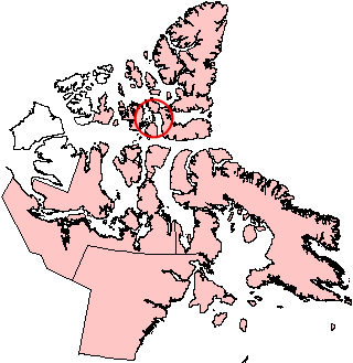
Baillie-Hamilton Island facts for kids

Baillie-Hamilton Island, Nunavut
|
|
| Geography | |
|---|---|
| Location | Northern Canada |
| Coordinates | 75°53′N 94°35′W / 75.883°N 94.583°W |
| Archipelago | Queen Elizabeth Islands Canadian Arctic Archipelago |
| Area | 290 km2 (110 sq mi) |
| Length | 27 km (16.8 mi) |
| Width | 22 km (13.7 mi) |
| Administration | |
|
Canada
|
|
| Territory | Nunavut |
| Demographics | |
| Population | Uninhabited |
Baillie-Hamilton Island is one of the many islands in the Canadian Arctic Archipelago. This island is located in Nunavut, which is a large territory in northern Canada.
The island has a shape like a rectangle. It is about 26 to 12 kilometers long and covers an area of 290 square kilometers.
Baillie-Hamilton Island is surrounded by several other, larger islands. To its north and east, you'll find Devon Island, with the Wellington Channel in between. To the south is Cornwallis Island, separated by the Maury Channel. And to the west, across the Queens Channel, lies Bathurst Island.
See also
 In Spanish: Isla Baillie-Hamilton para niños
Black History Month on Kiddle
Influential African-American Artists:
 | James Van Der Zee |
 | Alma Thomas |
 | Ellis Wilson |
 | Margaret Taylor-Burroughs |

All content from Kiddle encyclopedia articles (including the article images and facts) can be freely used under Attribution-ShareAlike license, unless stated otherwise. Cite this article:
Baillie-Hamilton Island Facts for Kids. Kiddle Encyclopedia.


