
Ballwin, Missouri facts for kids
Quick facts for kids
Ballwin, Missouri
|
|
|---|---|

Vlasis Park in Ballwin, Missouri, March 2000
|
|

Location of Ballwin in St. Louis County and Missouri
|
|

Ballwin, Missouri
Location in Missouri

Ballwin, Missouri
Location in the United States

Ballwin, Missouri
Location in North America
|
|
| Country | |
| State | |
| County | St. Louis |
| Incorporated | December 29, 1950 |
| Area | |
| • Total | 8.98 sq mi (23.26 km2) |
| • Land | 8.98 sq mi (23.26 km2) |
| • Water | 0.00 sq mi (0.00 km2) |
| Elevation | 623 ft (190 m) |
| Population
(2020)
|
|
| • Total | 31,103 |
| • Density | 3,463.20/sq mi (1,337.21/km2) |
| Time zone | UTC−6 (Central (CST)) |
| • Summer (DST) | UTC−5 (CDT) |
| FIPS code | 29-03160 |
| GNIS feature ID | 2394057 |
| Website | ballwin.mo.us |
Ballwin is a city in Missouri, United States. It is a suburb located west of St. Louis in St. Louis County. In 2020, about 31,103 people lived there.
Contents
A Look at Ballwin's History
Ballwin started in 1837. It was named after John Ball, who settled here in 1804. The first post office opened in 1866.
Ballwin's Geography
Ballwin covers about 8.99 square miles (23.28 km2) of land. There is no water area within the city limits.
Who Lives in Ballwin?
Ballwin has grown a lot over the years. Here's how its population has changed:
| Historical population | |||
|---|---|---|---|
| Census | Pop. | %± | |
| 1850 | 84 | — | |
| 1880 | 159 | — | |
| 1960 | 5,710 | — | |
| 1970 | 10,656 | 86.6% | |
| 1980 | 12,656 | 18.8% | |
| 1990 | 21,816 | 72.4% | |
| 2000 | 31,283 | 43.4% | |
| 2010 | 30,404 | −2.8% | |
| 2020 | 31,103 | 2.3% | |
| U.S. Decennial Census | |||
Ballwin's Population in 2020
In 2020, there were 31,103 people living in Ballwin. There were 11,922 households. Most residents (81.1%) were White. About 8.8% were Asian, and 3.0% were African American. People of Hispanic or Latino background made up 3.1% of the population.
Ballwin's Population in 2010
In 2010, Ballwin had 30,404 people. There were 11,874 households. About 34.2% of households had children under 18. Most households (60.9%) were married couples. The average household had 2.56 people. The average family had 3.04 people.
The average age in Ballwin was 41.2 years. About 24.9% of residents were under 18. And 15.1% were 65 or older.
Schools in Ballwin
Ballwin has many schools for students. They are part of two main school districts.
Parkway School District
- Parkway West High School
- Claymont Elementary School
- Henry Elementary School
- Oak Brook Elementary School
- Sorrento Springs Elementary School
Rockwood School District
- Selvidge Middle School
- Ballwin Elementary School
- Westridge Elementary School
- Woerther Elementary School
Private Schools
Holy Infant School is a private Catholic school. It teaches students from pre-kindergarten through eighth grade.
Local Businesses
Lion's Choice is a popular fast food chain. It is known for its roast beef sandwiches. This company first started right here in Ballwin!
Places of Worship
Ballwin is home to many different churches, mosques, and synagogues.
Salem in Ballwin United Methodist Church is on Manchester Road. It was founded in 1846. The original church building was built in 1870. A special sign was found during renovations. It says "ehre sei gott in der höhe," which means "Glory to God in the highest." This church also helps an orphanage in South Africa.
Parks and Fun Activities
Ballwin has many great places for outdoor fun and activities.
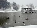
Vlasis Park
Vlasis Park is the biggest park in Ballwin. It covers 31 acres. You can find many things to do there:
- A baseball field
- A playground
- Four tennis courts
- Two ponds, one with fish
- Two picnic pavilions
- A walking path
- A sand volleyball court
Vlasis Park also hosts the yearly Ballwin Days Festival.
Other Parks and Facilities
- New Ballwin Park
- Ferris Park
- Greenfield Commons
- Holloway Park
The Pointe at Ballwin Commons has an indoor pool and a fitness center. The North Pointe Aquatic Center is an outdoor pool. It is open only during the summer. Next to North Pointe is the Ballwin Golf Course.
Famous People from Ballwin
- Jansen Miller, a professional soccer player for Sporting Kansas City.
Images for kids
-
Vlasis Park in Ballwin, Missouri, March 2000
See Also
 In Spanish: Ballwin (Misuri) para niños
