Balsha Island facts for kids

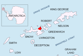
Location of Varna Peninsula on Livingston Island in the South Shetland Islands
|
|
|
Location of Balsha Island
|
|
| Geography | |
|---|---|
| Location | Antarctica |
| Coordinates | 62°28′24″S 60°11′35″W / 62.47333°S 60.19306°W |
| Archipelago | Dunbar Islands South Shetland Islands |
| Area | 0.17 km2 (0.066 sq mi) |
| Length | 0.6 km (0.37 mi) |
| Width | 0.3 km (0.19 mi) |
| Administration | |
| Administered under the Antarctic Treaty System | |
| Demographics | |
| Population | Uninhabited |
Balsha Island is a small island in Antarctica. It is special because it is mostly free of ice. This island is part of the Dunbar Islands group. It is located near the northwest coast of Varna Peninsula. Varna Peninsula is on Livingston Island. Livingston Island is part of the South Shetland Islands.
Balsha Island is about 1.5 kilometers (0.9 miles) northwest of a place called Slab Point. It is also about 2.8 kilometers (1.7 miles) north of Kotis Point. The island is about 600 meters (656 yards) long and 300 meters (328 yards) wide. Its total area is about 17 hectares (42 acres).
In the early 1800s, people who hunted seals visited this area. The island gets its name from a town called Balsha, Bulgaria in western Bulgaria.
Where is Balsha Island?
Balsha Island is located at 62°28′24″S 60°11′35″W. This is a set of coordinates that helps pinpoint its exact spot on a map.
Scientists from Bulgaria mapped the island. This happened during the Tangra 2004/05 expedition. Other countries have also mapped this area. British maps were made in 1968. Chilean maps came out in 1971. Argentine maps were created in 1980. Bulgarian maps were updated in 2005 and 2009. This shows how different countries help explore and understand Antarctica.


