
Banneville-sur-Ajon facts for kids
Quick facts for kids
Banneville-sur-Ajon
|
|
|---|---|
|
Part of Malherbe-sur-Ajon
|
|

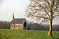
The Chapel of Saint Clair
|
|

Banneville-sur-Ajon
Location in France

Banneville-sur-Ajon
Location in Normandy
|
|
| Country | France |
| Region | Normandy |
| Department | Calvados |
| Arrondissement | Vire |
| Canton | Les Monts d'Aunay |
| Commune | Malherbe-sur-Ajon |
| Area
1
|
5.63 km2 (2.17 sq mi) |
| Population
(2019)
|
438 |
| • Density | 77.80/km2 (201.5/sq mi) |
| Time zone | UTC+01:00 (CET) |
| • Summer (DST) | UTC+02:00 (CEST) |
| Postal code |
14260
|
| Elevation | 84–184 m (276–604 ft) (avg. 141 m or 463 ft) |
| 1 French Land Register data, which excludes lakes, ponds, glaciers > 1 km2 (0.386 sq mi or 247 acres) and river estuaries. | |
Banneville-sur-Ajon was once a small town, known as a "commune," in the north-west of France. It was located in the Calvados area, which is part of the Normandy region. On January 1, 2016, Banneville-sur-Ajon joined with another town called Malherbe-sur-Ajon to form a new, larger commune.
Contents
Where is Banneville-sur-Ajon?
Banneville-sur-Ajon is about 20 kilometers (around 12 miles) south-west of a bigger city called Caen. It's also about 7 kilometers (4 miles) south-east of Villers-Bocage. You could reach the town by taking the D121A road from Saint-Agnan-le-Malherbe in the south. This road goes right through the middle of the town. Another road, the D171, passes through the north-east part of the area.
Besides the main village, there are two smaller areas called hamlets: La Fêterie in the south and Gournay in the north. Most of the land around Banneville-sur-Ajon is used for farming.
Two rivers flow through this area. The Ajon river comes from the south-east and flows towards the north-west. It eventually joins another river called the Odon. The Orgeuil river starts in the south of the area and flows north-east, also joining the Ajon. There's also a smaller stream called the Ruisseau de la Rette that joins the Orgeuil.
 |
Épinay-sur-Odon | Landes-sur-Ajon | Vacognes-Neuilly | |
| Longvillers | Préaux-Bocage | |||
| Le Mesnil-au-Grain | Saint-Agnan-le-Malherbe | Maisoncelles-sur-Ajon |
What's in a Name?
The name Banneville-sur-Ajon has changed over time. In 1371, it was called Barneville sur Ajon. Experts believe the name comes from an old Germanic name, Benno. The "ville" part of the name is an old French word that means "rural domain" or "country estate." So, it likely meant "Benno's country estate" near the Ajon river.
Who Ran the Town?
Like all towns, Banneville-sur-Ajon had mayors who helped manage things. From 1995 until it merged in 2016, three different people served as mayor:
- Jacques Vahe (1995-2001)
- Annick Viel-Schneider (2001-2014)
- Marcel Pétré (2014-2016)
How Many People Lived Here?
The people who lived in Banneville-sur-Ajon were called Bannevillais (for boys and men) or Bannevillaises (for girls and women).
Over the years, the number of people living in Banneville-sur-Ajon changed. In 1793, there were 508 residents. The population slowly went down for many years, reaching a low of 211 people in 1968. After that, the population started to grow again. By 2012, about 383 people lived there.
Cool Places to See
Banneville-sur-Ajon has some interesting old buildings and sites.
The Chapel of Saint-Clair

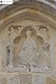
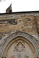
The Chapel of Saint-Clair was built a very long time ago, in the 13th century. It's considered an important historical building. The chapel has a simple rectangular shape. Above the main entrance, there's a special carving of Saint Samson sitting on his throne. Inside, you can find a statue of Saint Clair.
The Church of Saint-Melaine
The Church of Saint-Melaine was built later, in the late 1800s. It's designed in a style called neo-Gothic, which means it looks like the old Gothic churches but was built more recently.
A Special Grotto
After the Second World War, a copy of the famous grotto of Lourdes was built in an area called Le Village. A grotto is a small cave or a cave-like structure.
Chapel Picture Gallery
-
The Chapel of Saint Clair
-
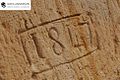
A Detail in the Chapel
-
The Chapel
-
Detail on the Chapel
-
The door handle of the Chapel


See also
 In Spanish: Banneville-sur-Ajon para niños
