Barberton, Washington facts for kids
Quick facts for kids
Barberton, Washington
|
|
|---|---|

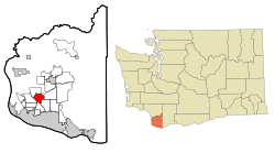
Location of Barberton, Washington
|
|
| Country | United States |
| State | Washington |
| County | Clark |
| Area | |
| • Total | 4.3 sq mi (11.2 km2) |
| • Land | 4.3 sq mi (11.2 km2) |
| • Water | 0 sq mi (0.0 km2) |
| Elevation | 246 ft (75 m) |
| Population
(2020)
|
|
| • Total | 8,567 |
| • Density | 1,981/sq mi (765/km2) |
| Time zone | UTC-8 (Pacific (PST)) |
| • Summer (DST) | UTC-7 (PDT) |
| FIPS code | 53-04195 |
| GNIS feature ID | 1503161 |
Barberton is a small community in Clark County, Washington, United States. It's known as a census-designated place (CDP). This means it's an area that the government counts for population, but it's not officially a city or town with its own local government.
In 2020, about 8,567 people lived in Barberton. It's considered one of the more well-off areas in Washington state based on how much money people earn there.
| Top - 0-9 A B C D E F G H I J K L M N O P Q R S T U V W X Y Z |
History of Barberton
Barberton was first settled by pioneers in the 1800s. Many of these early settlers came from Ireland. They worked hard to clear the forests to create land for farming.
The community was first called St. John's. This name came from a church built there in 1868, also named St. John's. Later, the area was renamed Barberton. It got its new name from a man named Barber, who was the very first postmaster in the area.
Geography of Barberton
Barberton is located in the southwestern part of Clark County. It's part of a group of communities that are not officially cities, just north of Vancouver.
It shares borders with several other communities:
- Mount Vista to the north
- Brush Prairie to the east
- Five Corners to the southeast
- Walnut Grove to the south
- Salmon Creek to the southwest
Interstate 205, a major highway, runs along the southwest edge of Barberton. This highway separates Barberton from Salmon Creek and Walnut Grove. You can get onto I-205 from nearby exits in Walnut Grove and Mount Vista.
Barberton is about 9 miles (14.5 kilometers) south of downtown Vancouver. It's also about 17 miles (27.4 kilometers) south of downtown Portland, Oregon.
The United States Census Bureau says that Barberton covers a total area of about 11.2 square kilometers (4.3 square miles). All of this area is land.
Population and People
| Historical population | |||
|---|---|---|---|
| Census | Pop. | %± | |
| 2000 | 4,617 | — | |
| 2010 | 5,661 | 22.6% | |
| 2020 | 8,567 | 51.3% | |
| US Decennial Census 2020 Census |
|||
The population of Barberton has grown over the years.
- In 2000, there were 4,617 people.
- By 2010, the population increased to 5,661 people.
- In 2020, it reached 8,567 people.
In 2010, there were 2,086 households in Barberton. A household is a group of people living together in one home.
Many families with children live in Barberton. About 40.6% of households had children under 18 living with them. Most households, about 72.6%, were married couples living together. The average household had about 2.89 people.
The age of people living in Barberton varies:
- About 28.5% of the population was under 18 years old.
- About 27.7% was between 25 and 44 years old.
- About 28.9% was between 45 and 64 years old.
- About 8.6% was 65 years or older.
The median age in Barberton was 38 years old. This means half the people were younger than 38 and half were older.
Most people in Barberton are White (93.72%). Other groups include African American, Native American, Asian, and Pacific Islander. About 2.43% of the population was Hispanic or Latino.
See also
 In Spanish: Barberton (Washington) para niños

