
Barbury Castle facts for kids


Steep earthworks (with cowslips) looking northwards
|
|

Location in Wiltshire
|
|
| Location | Wiltshire |
|---|---|
| Region | GB |
| Coordinates | 51°29′07″N 1°47′11″W / 51.4853°N 1.7865°W |
| Type | landmark |
| Area | 12 acres (4.9 ha) |
| History | |
| Periods | Iron Age |
| Site notes | |
| Public access | yes, The Ridgeway |

Barbury Castle is an amazing ancient hill fort in Wiltshire, England. It's a special place from the Iron Age, a time long, long ago. You can find it along the famous Ridgeway walking path.
This historic site is part of the beautiful Wessex Downs Area of Outstanding Natural Beauty. Since 1971, Swindon Borough Council has looked after it as a country park. Barbury Castle sits on Barbury Hill, a great spot to see far and wide. On a clear day, you can even see the Cotswolds and the River Severn!
The fort has two deep ditches and tall earth walls that were built for defense. The old Ridgeway path runs very close by. The modern Ridgeway path actually goes right through the castle. Around the area, you can also find ancient burial mounds called round barrows. There are also old Celtic farm fields and places where people dug for flint in the 1700s and 1800s.
Discovering Barbury Castle's Past


People first lived at Barbury Castle about 2,500 years ago. It was also used during the time of the Romans in the area. Archeologists have found signs of many buildings here. This suggests it might have been a village or a military camp back then.
In the 500s AD, Barbury became part of the Saxon kingdom of Wessex. This happened after a big battle called the Battle of Beran Byrig in AD 556. This battle took place just north of the castle.
Centuries later, in the 1800s, a writer named Richard Jefferies loved visiting this area. He lived only an hour's walk away.
During World War II, the US Army Air Force used the site for anti-aircraft guns. You can still see hollows around the fort's edge where their bases might have been.
In 1996, a special survey found traces of 40 hut circles inside the castle. These were round foundations where homes once stood. In 2006, a reconstruction of an Iron Age roundhouse was built on the site. Sadly, vandals destroyed it in October 2008.
In 2009, English Heritage (now called Historic England) studied aerial photographs of the area. They looked for all the ancient features visible from above around Barbury Castle. This helped them understand more about its history.
Where is Barbury Castle Located?


Barbury Castle is about 5 miles (8 km) south of Swindon. It's also near the M4 highway. You'll find it on the northern edge of the Marlborough Downs. This area is part of the beautiful North Wessex Downs Area of Outstanding Natural Beauty. There are only a couple of farms nearby, so it's a very quiet spot.
You can reach the site by car using a single road. This road climbs up the scarp (a steep slope) from the B4005 between Wroughton and Chiseldon. If you prefer walking or horseback riding, you have more choices. The Ridgeway path runs east-west along the downs. There's also a byway (a public path) that goes south across the downs to Marlborough.
Nearby towns and cities: Swindon, Marlborough
Nearby villages: Wroughton, Chiseldon
Images for kids
-
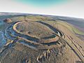
Barbury Castle, aerial view
-
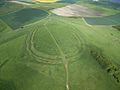
Another view of Barbury Castle from above
.jpg)
