
Barre, Tarn facts for kids
Quick facts for kids
Barre
|
|
|---|---|
_mairie_ecole.JPG)
The town hall and school in Barre
|
|

Barre
Location in France

Barre
Location in Occitanie
|
|
| Country | France |
| Region | Occitanie |
| Department | Tarn |
| Arrondissement | Castres |
| Canton | Les Hautes Terres d'Oc |
| Intercommunality | Monts de Lacaune |
| Area
1
|
15.07 km2 (5.82 sq mi) |
| Population
(Jan. 2019)
|
208 |
| • Density | 13.80/km2 (35.75/sq mi) |
| Time zone | UTC+01:00 (CET) |
| • Summer (DST) | UTC+02:00 (CEST) |
| INSEE/Postal code |
81023 /81320
|
| Elevation | 857–1,065 m (2,812–3,494 ft) (avg. 930 m or 3,050 ft) |
| 1 French Land Register data, which excludes lakes, ponds, glaciers > 1 km2 (0.386 sq mi or 247 acres) and river estuaries. | |
Barre is a small town, also called a commune, located in the Tarn department. This area is part of the Occitanie region in the southern part of France. It's a quiet place with a small population.
Geography of Barre
The area around Barre is quite hilly, meaning it has many ups and downs. Barre is situated right on the edge of the Tarn department. This means it's close to the border with other parts of France. The highest point in Barre is 1065 meters (about 3,494 feet) above sea level, and the lowest is 857 meters (about 2,812 feet).
Getting Around Barre
Roads in Barre
The main road that goes through Barre is called the D62. This road helps connect Barre to other nearby towns and villages. It is important for people living in Barre to travel and for goods to be moved in and out of the commune.
Images for kids
-
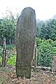
A Statue menhir called Cantoul, an ancient carved stone.

See also
 In Spanish: Barre para niños
