Barrett Island facts for kids
|
Location in Antarctica
|
|
| Geography | |
|---|---|
| Location | Antarctica |
| Coordinates | 72°12′S 95°33′W / 72.200°S 95.550°W |
| Administration | |
| Administered under the Antarctic Treaty System | |
| Demographics | |
| Population | Uninhabited |
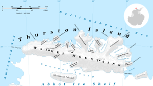
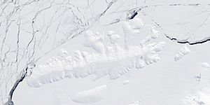
Barrett Island is a small, ice-covered island located in the cold, icy continent of Antarctica. It is about 4 kilometres (2 nmi) long. This island sits right at the northern entrance of Morgan Inlet, which is a bay on Thurston Island.
Exploring Barrett Island
Barrett Island is completely covered in ice, making it a part of Antarctica's frozen landscape. It's not a place where people live, as it's too cold and remote. The island's location near Thurston Island and Morgan Inlet means it's surrounded by the vast, icy waters of the Antarctic region.
How Barrett Island Got Its Name
Barrett Island was first mapped by the United States Geological Survey (USGS). This mapping work happened between 1960 and 1966. They used information from ground surveys and also from air photos taken by the United States Navy.
The island was later named by the Advisory Committee on Antarctic Names. They chose to name it after Lieutenant Barry B. Barrett. He was a pilot in Squadron VX-6 of the U.S. Navy. Lieutenant Barrett flew many important photographic missions during a big U.S. Navy operation called Operation Deep Freeze in 1964. These flights helped scientists and explorers learn more about the Antarctic continent.
 | James Van Der Zee |
 | Alma Thomas |
 | Ellis Wilson |
 | Margaret Taylor-Burroughs |


