Bartlett, Nebraska facts for kids
Quick facts for kids
Bartlett, Nebraska
|
|
|---|---|
|
Village
|
|

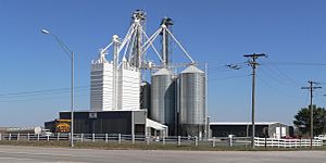
Bartlett Foods feed mill at Bartlett
|
|

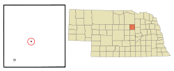
Location of Bartlett, Nebraska
|
|
| Country | United States |
| State | Nebraska |
| County | Wheeler |
| Area | |
| • Total | 0.14 sq mi (0.37 km2) |
| • Land | 0.14 sq mi (0.37 km2) |
| • Water | 0.00 sq mi (0.00 km2) |
| Elevation | 2,182 ft (665 m) |
| Population
(2020)
|
|
| • Total | 109 |
| • Density | 767.61/sq mi (296.21/km2) |
| Time zone | UTC-6 (Central (CST)) |
| • Summer (DST) | UTC-5 (CDT) |
| ZIP code |
68622
|
| Area code(s) | 308 |
| FIPS code | 31-03145 |
| GNIS feature ID | 2398042 |
Bartlett is a small village in Nebraska, United States. It is also the county seat of Wheeler County. This means it's the main town where the county government offices are located. In 2020, about 109 people lived in Bartlett.
Contents
The Story of Bartlett
Bartlett started as a town in the 1880s. It was named after Ezra Bartlett Mitchell. He was the person who first owned the land where the village now stands.
Where is Bartlett?
Bartlett is a small place. It covers about 0.37 square kilometers (or 0.14 square miles). All of this area is land, with no lakes or rivers inside the village limits.
What's the Weather Like?
Bartlett has a climate with warm summers and cold winters. The hottest month is usually July, and the coldest is January. It gets a fair amount of rain, especially in spring and summer.
Who Lives in Bartlett?
| Historical population | |||
|---|---|---|---|
| Census | Pop. | %± | |
| 1920 | 132 | — | |
| 1930 | 133 | 0.8% | |
| 1940 | 176 | 32.3% | |
| 1950 | 145 | −17.6% | |
| 1960 | 125 | −13.8% | |
| 1970 | 140 | 12.0% | |
| 1980 | 144 | 2.9% | |
| 1990 | 131 | −9.0% | |
| 2000 | 128 | −2.3% | |
| 2010 | 117 | −8.6% | |
| 2020 | 109 | −6.8% | |
| U.S. Decennial Census | |||
In 2010, there were 117 people living in Bartlett. These people made up 59 households and 30 families. Most of the people living there were White.
About 20% of the households had children under 18 living with them. Many households were married couples. The average age of people in the village was about 42 years old.
See also
 In Spanish: Bartlett (Nebraska) para niños
 | Anna J. Cooper |
 | Mary McLeod Bethune |
 | Lillie Mae Bradford |

