
Wheeler County, Nebraska facts for kids
Quick facts for kids
Wheeler County
|
|
|---|---|
_from_NW.JPG)
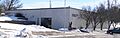
Wheeler County Courthouse in Bartlett
|
|

Location within the U.S. state of Nebraska
|
|
 Nebraska's location within the U.S. |
|
| Country | |
| State | |
| Founded | 1877 (created) April 11, 1881 (organized) |
| Named for | Daniel H. Wheeler |
| Seat | Bartlett |
| Largest village | Bartlett |
| Area | |
| • Total | 576 sq mi (1,490 km2) |
| • Land | 575 sq mi (1,490 km2) |
| • Water | 0.4 sq mi (1 km2) 0.07%% |
| Population
(2020)
|
|
| • Total | 774 |
| • Density | 1.3438/sq mi (0.5188/km2) |
| Time zone | UTC−6 (Central) |
| • Summer (DST) | UTC−5 (CDT) |
| Congressional district | 3rd |
Wheeler County is a place in Nebraska, a state in the United States. In 2020, about 774 people lived there. The main town, or "county seat," is Bartlett.
Wheeler County was created in 1877 and officially started working in 1881. It was named after Major Daniel H. Wheeler. He was an important secretary for Nebraska's State Board of Agriculture for many years.
If you look at Nebraska license plates, cars from Wheeler County have the number 84. This is because it had the 84th largest number of cars registered in the state back in 1922.
Contents
Wheeler County's Location and Land
Wheeler County has gently rolling hills that slope towards the east. A stream called Beaver Creek flows through the northern part of the county. It then exits near the middle of the county's eastern border.
The county covers an area of about 576 square miles (1,492 square kilometers). Almost all of this land is dry, with only a tiny bit (0.07%) being water.
Main Roads in Wheeler County
 U.S. Highway 281
 Nebraska Highway 70
 Nebraska Highway 91
Neighboring Counties
Wheeler County shares borders with several other counties:
- Antelope County – to the northeast
- Boone County – to the southeast
- Greeley County – to the south
- Valley County – to the southwest
- Garfield County – to the west
- Holt County – to the north
Special Natural Areas
- Pibel Lake State Recreation Area is a protected area where people can enjoy nature.
Wheeler County's Past
Wheeler County was officially allowed to form in 1877. It was fully set up in 1881. This happened because the town of Cumminsville was growing fast. People expected a Union Pacific Railroad line to pass through it.
The first county government was in a place called Cedar City. This county was originally much larger. On November 25, 1884, it was cut in half. The western part became Garfield County. The rest stayed as Wheeler County with its current borders.
The county was run by three commissioners. In 1885, their small courthouse in Cedar City was getting too small. Two men offered land outside Cedar City for a new courthouse. One of them was Ezra Bartlett Mitchell. His land was chosen after a vote. The new courthouse led to a new town being built around it. This town was named Bartlett, after Mitchell's middle name. Cedar City soon became empty after the government moved.
In 1886, a special train track was built into the county. It ended where the town of Ericson was later founded.
In 1895, people tried to build a ditch to water farms between Ericson and Spalding. They built a dam across Clear Creek. Even though the ditch didn't work out, the dam created what we now know as Pibel Lake.
Wheeler County's population started to get smaller after 1900. But in 1904, a new law called the Kinkaid Act brought more settlers. This helped the population grow again.
People of Wheeler County
| Historical population | |||
|---|---|---|---|
| Census | Pop. | %± | |
| 1880 | 644 | — | |
| 1890 | 1,683 | 161.3% | |
| 1900 | 1,362 | −19.1% | |
| 1910 | 2,292 | 68.3% | |
| 1920 | 2,531 | 10.4% | |
| 1930 | 2,335 | −7.7% | |
| 1940 | 2,170 | −7.1% | |
| 1950 | 1,526 | −29.7% | |
| 1960 | 1,297 | −15.0% | |
| 1970 | 1,051 | −19.0% | |
| 1980 | 1,060 | 0.9% | |
| 1990 | 948 | −10.6% | |
| 2000 | 886 | −6.5% | |
| 2010 | 818 | −7.7% | |
| 2020 | 774 | −5.4% | |
| 2022 (est.) | 785 | −4.0% | |
| US Decennial Census 1790-1960 1900-1990 1990-2000 2010 2020 2022 |
|||
In 2000, there were 886 people living in Wheeler County. There were 352 households, which are groups of people living together. About 243 of these were families. The county had about 1.5 people per square mile.
Most people in the county (99.10%) were White. A small number were Native American or from other backgrounds. About 0.56% of the people were Hispanic or Latino. Many residents had German (47.4%), Irish (9.4%), English (7.8%), or Swedish (7.2%) roots.
About 31.80% of households had children under 18 living with them. Most households (62.80%) were married couples. The average household had 2.52 people.
The median age in the county was 40 years old. About 29.10% of the population was under 18. About 16.80% were 65 years or older.
Towns and Villages
Villages
Past Communities
These are places that used to be towns or villages in Wheeler County:
- Cumminsville
- Cedar City
- Wheeler
Images for kids
-
Wheeler County Courthouse in Bartlett
See also
 In Spanish: Condado de Wheeler (Nebraska) para niños
