Valley County, Nebraska facts for kids
Quick facts for kids
Valley County
|
|
|---|---|

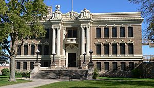
Valley County Courthouse in Ord
|
|

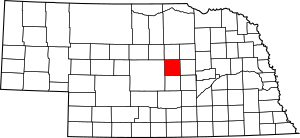
Location within the U.S. state of Nebraska
|
|
 Nebraska's location within the U.S. |
|
| Country | |
| State | |
| Founded | 1871 (formed) 1873 (organized) |
| Seat | Ord |
| Largest city | Ord |
| Area | |
| • Total | 570 sq mi (1,500 km2) |
| • Land | 568 sq mi (1,470 km2) |
| • Water | 2.4 sq mi (6 km2) 0.4%% |
| Population
(2020)
|
|
| • Total | 4,059 |
| • Density | 7.12/sq mi (2.749/km2) |
| Time zone | UTC−6 (Central) |
| • Summer (DST) | UTC−5 (CDT) |
| Congressional district | 3rd |
Valley County is a county in Nebraska, a state in the United States. In 2020, about 4,059 people lived there. The main town, or county seat, is Ord.
If you see a Nebraska license plate with '47' at the start, it means the car is from Valley County. This number was given in 1922 because it was the 47th county with the most registered cars.
Contents
History of Valley County
Valley County was created in 1871 and officially started operating in 1873. Its name comes from the area's landscape. A lot of the county is made up of valley land. This land lies between the North Loup River and the Middle Loup River.
On June 12, 2010, a private dam called Bredthauer Dam broke. This happened because of heavy rain. The water flooded parts of rural Valley County and the village of North Loup. The flood was serious in North Loup, with water about eight inches deep on Main Street. People in North Loup had to leave their homes until the flood waters went down.
Geography of Valley County
The North Loup River flows through the northern part of the county. The Middle Loup River flows through the southern part. The land here has rolling hills. The flat river valleys are mostly used for farming. Some farms use center pivot irrigation, which helps water crops in a circular pattern.
Valley County covers about 570 square miles. Most of this (568 square miles) is land, and a small part (2.4 square miles) is water.
Main Roads in Valley County
Special Places to Visit
- Fort Hartsuff State Historical Park
- Scotia Canal State Wildlife Management Area
Neighboring Counties
- Wheeler County – to the northeast
- Greeley County – to the east
- Sherman County – to the south
- Custer County – to the west
- Garfield County – to the north
People of Valley County
| Historical population | |||
|---|---|---|---|
| Census | Pop. | %± | |
| 1880 | 2,324 | — | |
| 1890 | 7,092 | 205.2% | |
| 1900 | 7,339 | 3.5% | |
| 1910 | 9,480 | 29.2% | |
| 1920 | 9,823 | 3.6% | |
| 1930 | 9,533 | −3.0% | |
| 1940 | 8,163 | −14.4% | |
| 1950 | 7,252 | −11.2% | |
| 1960 | 6,590 | −9.1% | |
| 1970 | 5,783 | −12.2% | |
| 1980 | 5,633 | −2.6% | |
| 1990 | 5,169 | −8.2% | |
| 2000 | 4,647 | −10.1% | |
| 2010 | 4,260 | −8.3% | |
| 2020 | 4,059 | −4.7% | |
| US Decennial Census 1790-1960 1900-1990 1990-2000 2010 |
|||
In 2000, there were 4,647 people living in Valley County. Most people were White (98.15%). A small number were from other racial backgrounds. About 1.61% of the population was Hispanic or Latino.
The average age of people in the county was 44 years old. About 24.70% of the population was under 18. Also, 24.00% of the people were 65 or older.
Towns and Villages
City
- Ord (This is the county seat, the main town for the county's government.)
Villages
Other Communities
These are smaller places that are not officially cities or villages.
Townships
- Arcadia
- Davis Creek
- Elyria
- Enterprise
- Eureka
- Geranium
- Independent
- Liberty
- Michigan
- Noble
- North Loup
- Ord
- Springdale
- Vinton
- Yale
See also
 In Spanish: Condado de Valley (Nebraska) para niños
 | Jewel Prestage |
 | Ella Baker |
 | Fannie Lou Hamer |

