Sherman County, Nebraska facts for kids
Quick facts for kids
Sherman County
|
|
|---|---|

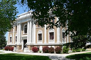
Sherman County Courthouse in Loup City
|
|

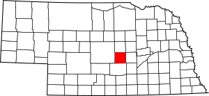
Location within the U.S. state of Nebraska
|
|
 Nebraska's location within the U.S. |
|
| Country | |
| State | |
| Founded | 1870 (founded) 1872 (organized) |
| Named for | William Tecumseh Sherman |
| Seat | Loup City |
| Largest city | Loup City |
| Area | |
| • Total | 572 sq mi (1,480 km2) |
| • Land | 566 sq mi (1,470 km2) |
| • Water | 5.8 sq mi (15 km2) 1.0%% |
| Population
(2020)
|
|
| • Total | 2,959 |
| • Density | 5.173/sq mi (1.9973/km2) |
| Time zone | UTC−6 (Central) |
| • Summer (DST) | UTC−5 (CDT) |
| Congressional district | 3rd |
Sherman County is a county located in the state of Nebraska in the United States. In 2020, about 2,959 people lived there. The main town and county seat is Loup City.
The county was started in 1870 and officially organized in 1872. It was named after William Tecumseh Sherman, a famous general from the American Civil War.
If you look at Nebraska license plates, cars from Sherman County have the number 56. This is because it had the fifty-sixth largest number of registered vehicles when the license plate system began in 1922.
Contents
About the Land
Sherman County has rolling hills that gently slope towards the southeast. A lot of the land is used for farming. The Middle Loup River flows through the eastern middle part of the county. Other smaller streams, like Clear Creek and Muddy Creek, flow through the western parts.
The county covers a total area of 572 square miles. Most of this, about 566 square miles, is land. The rest, about 5.8 square miles, is water.
Main Roads
These are the most important roads that go through Sherman County:
Neighboring Counties
Sherman County shares its borders with these other counties:
- Howard County – to the east
- Buffalo County – to the south
- Custer County – to the west
- Valley County – to the north
- Greeley County – to the northeast
Special Areas
- Sherman Reservoir State Recreation Area is a protected area where people can enjoy nature and outdoor activities.
People in Sherman County
| Historical population | |||
|---|---|---|---|
| Census | Pop. | %± | |
| 1880 | 2,061 | — | |
| 1890 | 6,399 | 210.5% | |
| 1900 | 6,550 | 2.4% | |
| 1910 | 8,278 | 26.4% | |
| 1920 | 8,877 | 7.2% | |
| 1930 | 9,122 | 2.8% | |
| 1940 | 7,764 | −14.9% | |
| 1950 | 6,421 | −17.3% | |
| 1960 | 5,382 | −16.2% | |
| 1970 | 4,725 | −12.2% | |
| 1980 | 4,226 | −10.6% | |
| 1990 | 3,718 | −12.0% | |
| 2000 | 3,318 | −10.8% | |
| 2010 | 3,152 | −5.0% | |
| 2020 | 2,959 | −6.1% | |
| U.S. Decennial Census 1790-1960 1900-1990 1990-2000 2010 |
|||
In 2020, the population of Sherman County was 2,959 people. The county has seen its population change over the years, as shown in the chart above.
Most people living in Sherman County are White. A small number of people are from other racial backgrounds. About 1% of the population is of Hispanic or Latino origin.
In 2000, about 22.4% of the people were under 18 years old. About 23.4% were 65 years or older. The average age was 47.8 years. Slightly more than half of the population (50.9%) were female.
Sherman County is known for having one of the largest Polish-American communities in Nebraska and even in the country. In 2000, nearly 30% of the people in Sherman County had Polish family backgrounds.
Towns and Villages
Cities
- Loup City is the main city and the county seat.
Villages
See also
 In Spanish: Condado de Sherman (Nebraska) para niños
 | Leon Lynch |
 | Milton P. Webster |
 | Ferdinand Smith |

