Custer County, Nebraska facts for kids
Quick facts for kids
Custer County
|
|
|---|---|

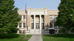
Custer County Courthouse in Broken Bow
|
|

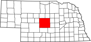
Location within the U.S. state of Nebraska
|
|
 Nebraska's location within the U.S. |
|
| Country | |
| State | |
| Founded | February 17, 1877 |
| Named for | George Armstrong Custer |
| Seat | Broken Bow |
| Largest city | Broken Bow |
| Area | |
| • Total | 2,576 sq mi (6,670 km2) |
| • Land | 2,576 sq mi (6,670 km2) |
| • Water | 0.4 sq mi (1 km2) 0.01% |
| Population | |
| • Estimate
(2021)
|
10,460 |
| • Density | 4.06/sq mi (1.57/km2) |
| Time zone | UTC−6 (Central) |
| • Summer (DST) | UTC−5 (CDT) |
| Congressional district | 3rd |
Custer County is a county located in the state of Nebraska, USA. It is known for its wide-open spaces and agricultural roots. As of the 2020 United States Census, about 10,545 people live here.
The main town and county seat is Broken Bow. Custer County was officially created in 1877. It was named after General George Armstrong Custer, a famous military leader.
In Nebraska's license plate system, Custer County uses the number 4. This is because it had the fourth-largest number of vehicles registered in the state when the system started in 1922.
Contents
Geography of Custer County
Custer County covers a total area of about 2,576 square miles. Almost all of this area is land, with only a tiny bit of water. It is the second largest county in Nebraska by land area. Only Cherry County is bigger.
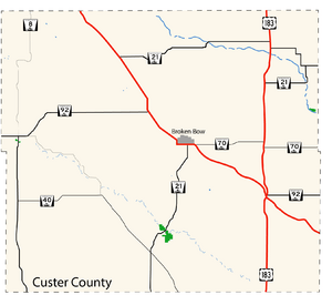
Main Roads in Custer County
These are the major highways that run through Custer County:
 U.S. Highway 183
 Nebraska Highway 2
 Nebraska Highway 21
 Nebraska Highway 40
 Nebraska Highway 47
 Nebraska Highway 70
 Nebraska Highway 92
Neighboring Counties
Custer County shares borders with these other counties:
- Valley County – to the northeast
- Sherman County – to the southeast
- Buffalo County – to the southeast
- Dawson County – to the south
- Lincoln County – to the southwest
- Logan County – to the west
- Blaine County – to the northwest
- Loup County – to the northeast
History of Custer County
Custer County was officially formed in 1877. It was named to honor General George Armstrong Custer. People started settling here even before it became an official county.
Early Settlers and Challenges
This area was once home to the Sioux people. After some conflicts, the land became available for new settlers. The first pioneers arrived in the early 1870s. They were looking for land through the Homestead Act of 1862. This act allowed people to claim land if they lived on it and farmed it for a few years.
These early settlers faced many challenges. They dealt with tough weather, being far from other towns, and trying to farm in what was then a very dry area. Since there were not many trees, they often built homes called sod houses using blocks of grass and soil. They chose places near water sources to build their settlements.
The Railroad's Impact
In the early 1880s, the Burlington Railroad built tracks through Custer County. This was a huge help for the area. The railroad made it easier for more settlers to arrive. It also allowed farmers to transport their crops and goods to other places.
The railroad helped towns like Broken Bow grow. Broken Bow became the county seat, which is the main town where the county government is located. The railroad helped the county shift from mainly raising cattle to growing more crops like wheat and corn.
Growth and Community Life
By the early 1900s, Custer County had grown a lot. Communities built schools, churches, and other important places. This showed that the area was no longer just a frontier settlement. It was becoming a well-organized and thriving community.
Population of Custer County
Custer County has seen its population change over the years. Here is a look at how many people have lived in the county during different census years:
| Historical population | |||
|---|---|---|---|
| Census | Pop. | %± | |
| 1880 | 2,211 | — | |
| 1890 | 21,677 | 880.4% | |
| 1900 | 19,758 | −8.9% | |
| 1910 | 25,668 | 29.9% | |
| 1920 | 26,407 | 2.9% | |
| 1930 | 26,189 | −0.8% | |
| 1940 | 22,591 | −13.7% | |
| 1950 | 19,170 | −15.1% | |
| 1960 | 16,517 | −13.8% | |
| 1970 | 14,092 | −14.7% | |
| 1980 | 13,877 | −1.5% | |
| 1990 | 12,270 | −11.6% | |
| 2000 | 11,793 | −3.9% | |
| 2010 | 10,939 | −7.2% | |
| 2020 | 10,545 | −3.6% | |
| 2021 (est.) | 10,460 | −4.4% | |
| US Decennial Census 1790-1960 1900-1990 1990-2000 2010-2013 |
|||
In 2000, there were 11,793 people living in Custer County. The population density was about 5 people per square mile. Most residents were White, with smaller numbers of other groups. About 37% of the people had German heritage.
The average household had about 2.39 people. About 30% of households had children under 18 living with them. The median age in the county was 41 years old.
Towns and Villages
Custer County has several towns and villages where people live.
Cities
- Broken Bow (This is the county seat)
- Sargent
Villages
Census-designated place
Unincorporated communities
These are smaller communities that are not officially organized as cities or villages:
See also
 In Spanish: Condado de Custer (Nebraska) para niños
 | Laphonza Butler |
 | Daisy Bates |
 | Elizabeth Piper Ensley |


