Sargent, Nebraska facts for kids
Quick facts for kids
Sargent, Nebraska
|
|
|---|---|

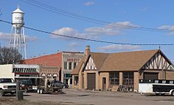
Downtown Sargent
|
|

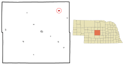
Location of Sargent, Nebraska
|
|
| Country | United States |
| State | Nebraska |
| County | Custer |
| Township | Sargent |
| Area | |
| • Total | 1.09 sq mi (2.81 km2) |
| • Land | 1.09 sq mi (2.81 km2) |
| • Water | 0.00 sq mi (0.00 km2) |
| Elevation | 2,313 ft (705 m) |
| Population
(2020)
|
|
| • Total | 500 |
| • Density | 460.41/sq mi (177.80/km2) |
| Time zone | UTC-6 (Central (CST)) |
| • Summer (DST) | UTC-5 (CDT) |
| ZIP code |
68874
|
| Area code(s) | 308 |
| FIPS code | 31-43685 |
| GNIS feature ID | 2396538 |
Sargent is a city located in Custer County, Nebraska, in the United States. In 2010, the city had a population of 525 people. By 2020, the population was 500.
Contents
History of Sargent
Sargent was first planned out in 1883 by Ezra P. Savage, who later became a governor.
How Sargent Got Its Name
The first post office in the area was set up in 1879 by Mrs. Ruth Sherman. It was located in a "soddy," which is a house built from sod (earth and grass). This was about half a mile east of where the city is now. Mrs. Sherman chose the name "Sargent" to honor her good friends, Mr. and Mrs. E.D. Sargent, who lived in Streator, Illinois.
Early Growth and the Railroad
In July 1883, J.K. Spacht built the very first store in what is now Sargent. It was built right in the middle of a wheat field! After opening his general store, Mr. Spacht convinced Mrs. Sherman to move the post office into his new store. She agreed, as long as the name "Sargent" stayed the same.
The town grew very quickly when the railroad arrived in 1899. This made it easier for people and goods to travel to and from Sargent.
Geography of Sargent
Sargent covers an area of about 1.07 square miles (2.81 square kilometers), and all of it is land.
Location and Nearby Features
The city is located on U.S. Route 183, which is also known as Ord Street. Sargent is very close to the exact center of Nebraska. It is also right next to the Middle Loup River, which is a natural waterway.
Population and People
| Historical population | |||
|---|---|---|---|
| Census | Pop. | %± | |
| 1900 | 250 | — | |
| 1910 | 651 | 160.4% | |
| 1920 | 1,078 | 65.6% | |
| 1930 | 834 | −22.6% | |
| 1940 | 847 | 1.6% | |
| 1950 | 818 | −3.4% | |
| 1960 | 876 | 7.1% | |
| 1970 | 789 | −9.9% | |
| 1980 | 828 | 4.9% | |
| 1990 | 710 | −14.3% | |
| 2000 | 649 | −8.6% | |
| 2010 | 525 | −19.1% | |
| 2020 | 500 | −4.8% | |
| U.S. Decennial Census 2018 Estimate |
|||
Sargent's Population in 2010
According to the census from 2010, there were 525 people living in Sargent. These people lived in 245 households, and 148 of those were families. The city had about 490 people per square mile (177 people per square kilometer). There were 318 housing units in total.
Most of the people living in Sargent were White (99.0%). A small number were African American (0.6%), Asian (0.2%), or from two or more races (0.2%). About 1.5% of the population identified as Hispanic or Latino.
Households and Age Groups
Out of the 245 households, about 25.7% had children under 18 living with them. Nearly half (48.2%) were married couples living together. About 36.3% of all households were made up of just one person. Around 20% of households had someone living alone who was 65 years old or older.
The average age of people in Sargent was 47.6 years. About 22.9% of residents were under 18 years old. People aged 65 or older made up 25% of the population. The city had a very similar number of males (50.1%) and females (49.9%).
See also

- In Spanish: Sargent (Nebraska) para niños
 | Isaac Myers |
 | D. Hamilton Jackson |
 | A. Philip Randolph |


