
Oconto, Nebraska facts for kids
Quick facts for kids
Oconto, Nebraska
|
|
|---|---|
|
Village
|
|

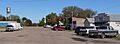
Welcome sign, windmill, sculptures (2010)
|
|

Location within Custer County and Nebraska
|
|

Oconto, Nebraska
Location in Nebraska

Oconto, Nebraska
Location in the United States
|
|
| Country | United States |
| State | Nebraska |
| County | Custer |
| Township | Wood River |
| Founded | 1887 |
| Incorporated | 1906 |
| Area | |
| • Total | 0.20 sq mi (0.53 km2) |
| • Land | 0.20 sq mi (0.53 km2) |
| • Water | 0.00 sq mi (0.00 km2) |
| Elevation | 2,566 ft (782 m) |
| Population
(2020)
|
|
| • Total | 138 |
| • Density | 679.80/sq mi (262.33/km2) |
| Time zone | UTC-6 (Central (CST)) |
| • Summer (DST) | UTC-5 (CDT) |
| ZIP code |
68860
|
| Area code | 308 |
| FIPS code | 31-35665 |
| GNIS ID | 2399555 |
Oconto is a small village located in Custer County, Nebraska, in the United States. In 2020, about 138 people lived there. It's a quiet place with a rich history and a strong community spirit.
Contents
History of Oconto
Oconto was first started in 1887. Its original name was Olax. However, there was another place in Nebraska with a similar name. So, the village was renamed Oconto. People aren't sure exactly where the name Oconto came from. Some think it was named after an early settler. Others believe it was named after a town called Oconto, Wisconsin. Oconto officially became a village in 1906.
Tornado Strikes Oconto
On October 31, 2000, a powerful tornado hit Oconto. It caused a lot of damage. The community center and several businesses in the downtown area were destroyed. About 40 homes were also damaged. Luckily, a Halloween party was happening at the community center when the tornado hit. Thanks to an early warning, all 19 children and 4 adults were able to go to the basement for safety. Everyone came out unharmed! In 2003, a new community center was built. Funds from the government and local groups helped pay for it.
Viewing a Total Solar Eclipse
On August 21, 2017, Oconto was a special place to be. It was directly in the path of a total solar eclipse. This is when the Moon passes right in front of the Sun, making the sky dark in the middle of the day. Hundreds of people, including tourists from other states, gathered in Oconto to watch this amazing natural event.
Geography of Oconto
Oconto is a small village, covering an area of about 0.53 square kilometers (0.20 square miles). All of this area is land.
The village is located where two Nebraska state highways meet: Highway 21 and Highway 40. It is also situated south of the Pressey Wildlife Management Area, a place where nature and animals are protected.
Population in Oconto
The number of people living in Oconto has changed over the years. Here's a look at the population from 1910 to 2020:
| Historical population | |||
|---|---|---|---|
| Census | Pop. | %± | |
| 1910 | 245 | — | |
| 1920 | 272 | 11.0% | |
| 1930 | 243 | −10.7% | |
| 1940 | 260 | 7.0% | |
| 1950 | 258 | −0.8% | |
| 1960 | 219 | −15.1% | |
| 1970 | 155 | −29.2% | |
| 1980 | 176 | 13.5% | |
| 1990 | 147 | −16.5% | |
| 2000 | 141 | −4.1% | |
| 2010 | 151 | 7.1% | |
| 2020 | 138 | −8.6% | |
| U.S. Decennial Census | |||
What the 2010 Census Showed
In 2010, there were 151 people living in Oconto. There were 68 households, which are groups of people living together. The average age of people in the village was about 44 years old. About 22% of the residents were under 18 years old.
Images for kids
-
Downtown Oconto in 2010
See also
 In Spanish: Oconto (Nebraska) para niños
