Loup County, Nebraska facts for kids
Quick facts for kids
Loup County
|
|
|---|---|

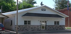
Loup County Courthouse in Taylor
|
|

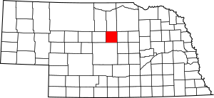
Location within the U.S. state of Nebraska
|
|
 Nebraska's location within the U.S. |
|
| Country | |
| State | |
| Founded | 1883 |
| Seat | Taylor |
| Largest village | Taylor |
| Area | |
| • Total | 571 sq mi (1,480 km2) |
| • Land | 568 sq mi (1,470 km2) |
| • Water | 2.8 sq mi (7 km2) 0.13%% |
| Population
(2020)
|
|
| • Total | 607 |
| • Density | 1.0630/sq mi (0.4104/km2) |
| Time zone | UTC−6 (Central) |
| • Summer (DST) | UTC−5 (CDT) |
| Congressional district | 3rd |
Loup County is a county located in the state of Nebraska in the United States. In 2020, about 607 people lived there. This makes it one of the smallest counties in Nebraska and also one of the smallest in the entire U.S. The main town and county seat (where the county government is) is Taylor. The county got its name from the Pawnee Loup Native American tribe.
If you look at Nebraska license plates, cars from Loup County have the number 88. This is because in 1922, when the license plate system started, Loup County had the 88th largest number of registered vehicles.
Contents
Geography of Loup County
Loup County has mostly flat land, which is used a little bit for farming. The land gently slopes down towards the southeast. Two important rivers flow through the county. The Calamus River flows southeast through the northern part of the county. It then goes into the Calamus Reservoir, which is on the county's eastern edge. The North Loup River also flows southeast through the lower middle part of the county. It leaves the county in the southeast and later joins the Calamus River.
The county covers an area of 571 square miles. Most of this (568 square miles) is land, and a small part (2.8 square miles) is water.
Main Roads in Loup County
Neighboring Counties
Loup County shares its borders with several other counties:
- Holt County to the northeast
- Garfield County to the east
- Custer County to the south
- Blaine County to the west
- Brown County to the northwest
- Rock County to the north
Nature and Recreation Areas
- Calamus River State Recreation Area: This is a protected area where people can enjoy nature, often for activities like fishing, boating, or camping.
People of Loup County
The number of people living in Loup County has changed over the years. In 1890, there were 1,662 people. The population grew to 2,188 in 1910, but then it slowly decreased. By 2020, the population was 607 people.
In 2000, there were 632 people living in the county. Most people (98.88%) were White. A small number were Native American or Asian. About 1.69% of the people were Hispanic or Latino.
There were 289 households in 2000. About 31.8% of these households had children under 18 living with them. Most households (64.7%) were married couples living together. The average household had about 2.46 people.
The average age of people in the county in 2000 was 43 years old. About 26.7% of the population was under 18, and 19.5% were 65 or older. For every 100 females, there were about 108.8 males.
The average income for a household in the county was $26,250 per year. For a family, it was $27,788. About 17.7% of all people in the county lived below the poverty line. This included 22.9% of those under 18 and 11.6% of those 65 or older.
Towns and Places
Main Village
- Taylor (This is the county seat, meaning it's where the county government offices are.)
Smaller Communities
These are places that are not officially organized as towns or cities:
- Almeria
- Pioneerville (In 2010, about 106 people lived here.)
Ghost Towns
These are towns that used to exist but are now abandoned:
- Clothstock: People lived here from 1899 to 1907. Its highest population was 38 people in 1906.
- Pickiner: People lived here from 1908 to 1926. Its highest population was 76 people in 1918.
See also
 In Spanish: Condado de Loup para niños
 | Jewel Prestage |
 | Ella Baker |
 | Fannie Lou Hamer |

