Howard County, Nebraska facts for kids
Quick facts for kids
Howard County
|
|
|---|---|

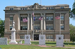
Howard County Courthouse in St. Paul
|
|

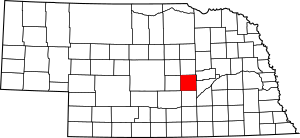
Location within the U.S. state of Nebraska
|
|
 Nebraska's location within the U.S. |
|
| Country | |
| State | |
| Founded | 1871 |
| Named for | Oliver O. Howard |
| Seat | St. Paul |
| Largest city | St. Paul |
| Area | |
| • Total | 576 sq mi (1,490 km2) |
| • Land | 569 sq mi (1,470 km2) |
| • Water | 6.3 sq mi (16 km2) 1.1%% |
| Population
(2020)
|
|
| • Total | 6,475 |
| • Density | 11.241/sq mi (4.340/km2) |
| Time zone | UTC−6 (Central) |
| • Summer (DST) | UTC−5 (CDT) |
| Congressional district | 3rd |
Howard County is a county located in the state of Nebraska in the United States. In 2020, about 6,475 people lived here. The main town, or county seat, is St. Paul. Howard County was created in 1871. It was named after Oliver Otis Howard, who was a general during the American Civil War.
Howard County is part of the Grand Island area. This means it's connected to the larger Grand Island city area.
If you look at Nebraska license plates, cars from Howard County have the number 49. This is because Howard County had the 49th highest number of registered vehicles when the license plate system started in 1922.
Contents
Howard County's Land and Rivers
Howard County has gentle, rolling hills. The flat tops of these hills are mostly used for farming. The Upper Loup River flows into the county from the northwest. It then turns east and meets the Middle Loup River.
The Middle Loup River flows into the county from the southwest. It turns north to join the Upper Loup River in the middle of the county. Together, they form the Loup River, which then flows east into Merrick County.
The county covers a total area of about 576 square miles. Most of this, about 569 square miles, is land. The rest, about 6.3 square miles, is water.
Main Roads in Howard County
Neighboring Counties
Howard County shares borders with several other counties:
- Merrick County to the east
- Hall County to the south
- Buffalo County to the southwest
- Sherman County to the west
- Greeley County to the north
Protected Natural Areas
- Loup Junction State Wildlife Management Area
People in Howard County
| Historical population | |||
|---|---|---|---|
| Census | Pop. | %± | |
| 1880 | 4,391 | — | |
| 1890 | 9,430 | 114.8% | |
| 1900 | 10,343 | 9.7% | |
| 1910 | 10,783 | 4.3% | |
| 1920 | 10,739 | −0.4% | |
| 1930 | 10,020 | −6.7% | |
| 1940 | 8,422 | −15.9% | |
| 1950 | 7,226 | −14.2% | |
| 1960 | 6,541 | −9.5% | |
| 1970 | 6,807 | 4.1% | |
| 1980 | 6,773 | −0.5% | |
| 1990 | 6,057 | −10.6% | |
| 2000 | 6,567 | 8.4% | |
| 2010 | 6,274 | −4.5% | |
| 2020 | 6,475 | 3.2% | |
| US Decennial Census 1790-1960 1900-1990 1990-2000 2010 |
|||
In 2000, there were 6,567 people living in Howard County. There were 2,546 households, which are groups of people living together. About 1,797 of these were families.
Most people in the county were White (98.69%). A small number were Black or African American (0.30%), Native American (0.24%), or Asian (0.09%). About 1.01% of the population was Hispanic or Latino.
About 33.80% of households had children under 18 living with them. Most households (61.00%) were married couples. About 15.00% of households had someone living alone who was 65 years old or older.
The average age of people in the county was 38 years old. About 28.30% of the population was under 18. About 17.10% were 65 years or older.
Towns and Villages
City
- St. Paul (This is the county seat, the main town where the county government is located.)
Villages
- Cotesfield
- Cushing
- Dannebrog
- Elba
- Farwell
- Howard City
- Wolbach (part of this village is in Howard County)
Census-Designated Place
- St. Libory (This is a community that is like a town but not officially incorporated as one.)
Unincorporated Communities
These are small communities that are not officially part of a city or village:
Images for kids
See also
 In Spanish: Condado de Howard (Nebraska) para niños
 | May Edward Chinn |
 | Rebecca Cole |
 | Alexa Canady |
 | Dorothy Lavinia Brown |


