
St. Libory, Nebraska facts for kids
Quick facts for kids
St. Libory, Nebraska
|
|
|---|---|

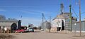
Spruce Street, St. Libory
|
|

St. Libory, Nebraska
Location in Nebraska

St. Libory, Nebraska
Location in the United States
|
|
| Country | United States |
| State | Nebraska |
| County | Howard |
| Area | |
| • Total | 0.33 sq mi (0.86 km2) |
| • Land | 0.33 sq mi (0.86 km2) |
| • Water | 0.00 sq mi (0.00 km2) |
| Elevation | 1,864 ft (568 m) |
| Population
(2020)
|
|
| • Total | 241 |
| • Density | 725.90/sq mi (280.25/km2) |
| Time zone | UTC-6 (Central (CST)) |
| • Summer (DST) | UTC-5 (CDT) |
| ZIP code |
68872
|
| FIPS code | 31-43160 |
| GNIS feature ID | 2583897 |
St. Libory is a small place in Nebraska, United States. It is known as an unincorporated community, which means it does not have its own local government like a city or town. It is also a census-designated place (CDP), which is an area the government uses to collect population data.
St. Libory is located in the southeastern part of Howard County. It is about 11 miles (18 km) southeast of St. Paul, which is the main town of Howard County. The community is found along U.S. Route 281, a major road. St. Libory is also known for its fresh melon market.
Population and People
St. Libory is a small community. In 2020, the population was 241 people. This means that fewer than 250 people live there.
| Historical population | |||
|---|---|---|---|
| Census | Pop. | %± | |
| 2020 | 241 | — | |
| U.S. Decennial Census | |||
History of St. Libory
St. Libory began to grow when the Union Pacific Railroad built its tracks through the area. The railroad helped connect the community to other places.
The community was named after another place called St. Libory, Illinois. The first post office in St. Libory, Nebraska, opened in 1878. This allowed people to send and receive mail.
Images for kids
-
Spruce Street, St. Libory
See also
 In Spanish: St. Libory (Nebraska) para niños
