Batha facts for kids
Quick facts for kids Batha Prefecture
Préfecture du Batha
|
|||||||||||
|---|---|---|---|---|---|---|---|---|---|---|---|
| Prefecture of Chad | |||||||||||
| 1960–1999 | |||||||||||
 |
|||||||||||
| Capital | Ati | ||||||||||
| Area | |||||||||||
| • Coordinates | 13°12′N 18°20′E / 13.200°N 18.333°E | ||||||||||
|
• 1960
|
100,000 km2 (39,000 sq mi) | ||||||||||
|
• 1993
|
88,800 km2 (34,300 sq mi) | ||||||||||
| Population | |||||||||||
|
• 1960
|
279,873 | ||||||||||
|
• 1993
|
288,458 | ||||||||||
| • Type | Prefecture | ||||||||||
| Historical era | Cold War | ||||||||||
|
• Established
|
13 February 1960 | ||||||||||
|
• Disestablished
|
1 September 1999 | ||||||||||
| Political subdivisions | Sub-prefectures (1993)
|
||||||||||
|
|||||||||||
| Area and population source: | |||||||||||
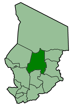
Batha Prefecture was a special administrative area in the country of Chad. It was like a large county or province. Chad used to be divided into 14 of these "prefectures" to help manage the country. Batha Prefecture was located right in the middle of Chad.
It was a very large area, covering about 88,800 square kilometers. To give you an idea, that's bigger than many small countries! In 1993, about 288,458 people lived there. The main city and capital of Batha Prefecture was called Ati.
Today, the land that was Batha Prefecture is mostly the same as the current Batha Region. This is how Chad is now divided into different areas.
Contents
What Was Batha Prefecture?
A prefecture was a type of administrative division. Think of it like a state or a large county. Chad used to be split into 14 of these prefectures. This system helped the government manage different parts of the country.
Batha Prefecture was one of these important areas. It played a role in how Chad was governed for many years.
Where Was Batha Prefecture Located?
Batha Prefecture was found in the central part of Chad. Chad is a country in Africa. Being in the center meant it was an important link between different regions. Its location helped connect various communities.
How Big Was Batha Prefecture?
This prefecture was quite large. It covered an area of 88,800 square kilometers. That's a huge amount of land! In 1993, a survey showed that 288,458 people lived in Batha Prefecture. This number tells us about the population density.
The Capital City: Ati
Every prefecture had a main city, known as its capital. For Batha Prefecture, the capital city was Ati. The capital city is usually where the main government offices are located. It serves as the center for business and daily life.
When Did Batha Prefecture Exist?
Batha Prefecture was established in 1960. It was part of Chad's administrative structure for several decades. The prefecture was eventually disestablished in 1999. This means it was no longer used as a way to divide the country.
How Chad is Organized Today
After 1999, Chad changed how it divided its land. The old prefectures were replaced with new administrative regions. The area that was Batha Prefecture is now mostly known as the Batha Region. This new system helps Chad manage its different areas more effectively.
|
|||
|
Batha · Biltine · Borkou-Ennedi-Tibesti · Chari-Baguirmi · Guéra · Kanem · Lac · Logone Occidental · Logone Oriental · Mayo-Kébbi · Moyen-Chari · Ouaddaï · Salamat · Tandjilé · |
|||
|
See also : Regions of Chad - Departments of Chad |
 | May Edward Chinn |
 | Rebecca Cole |
 | Alexa Canady |
 | Dorothy Lavinia Brown |


