Bayard, Iowa facts for kids
Quick facts for kids
Bayard, Iowa
|
|
|---|---|

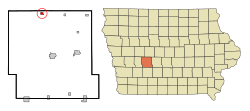
Location of Bayard, Iowa
|
|
| Country | |
| State | |
| County | Guthrie |
| Incorporated | June 14, 1883 |
| Area | |
| • Total | 0.44 sq mi (1.15 km2) |
| • Land | 0.44 sq mi (1.15 km2) |
| • Water | 0.00 sq mi (0.00 km2) |
| Elevation | 1,135 ft (346 m) |
| Population
(2020)
|
|
| • Total | 405 |
| • Density | 914.22/sq mi (352.87/km2) |
| Time zone | UTC-6 (Central (CST)) |
| • Summer (DST) | UTC-5 (CDT) |
| ZIP code |
50029
|
| Area code(s) | 712 |
| FIPS code | 19-04960 |
| GNIS feature ID | 2394088 |
Bayard is a small city located in Guthrie County, Iowa, in the United States. It's part of the larger Des Moines area. In 2020, about 405 people lived here. It's a quiet place with a history dating back to the 1880s.
Contents
History of Bayard
Bayard was officially planned and laid out in 1882. This means its streets and lots were mapped out before people started building homes and businesses there. The city was officially incorporated on June 14, 1883, which means it became an official town with its own local government.
Geography of Bayard
Bayard is a small city in terms of size. According to the United States Census Bureau, it covers a total area of about 1.15 square kilometers (or 0.44 square miles). All of this area is land, meaning there are no large lakes or rivers within the city limits.
Population and People
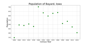
| Historical population | |||
|---|---|---|---|
| Census | Pop. | %± | |
| 1890 | 348 | — | |
| 1900 | 494 | 42.0% | |
| 1910 | 488 | −1.2% | |
| 1920 | 505 | 3.5% | |
| 1930 | 477 | −5.5% | |
| 1940 | 703 | 47.4% | |
| 1950 | 634 | −9.8% | |
| 1960 | 597 | −5.8% | |
| 1970 | 628 | 5.2% | |
| 1980 | 637 | 1.4% | |
| 1990 | 511 | −19.8% | |
| 2000 | 536 | 4.9% | |
| 2010 | 471 | −12.1% | |
| 2020 | 405 | −14.0% | |
| U.S. Decennial Census | |||
Bayard's Population in 2020
In 2020, the census counted 405 people living in Bayard. These people lived in 183 different homes, and 110 of these were families. The city had a population density of about 353 people per square kilometer (or 914 people per square mile). This means that for every square kilometer of land, there were about 353 people.
Most of the people in Bayard were White (about 91.4%). A small number of people were from other racial backgrounds or identified with two or more races. About 3% of the population identified as Hispanic or Latino.
The average age of people in Bayard was about 41.7 years old.
- About 26.4% of residents were under 20 years old.
- About 22.7% were between 25 and 44 years old.
- About 22.7% were 65 years old or older.
Slightly more than half of the population (51.4%) was male, and 48.6% was female.
Bayard's Population in 2010
Back in 2010, the census showed that 471 people lived in Bayard. There were 202 homes, with 121 of them being families. The population density was a bit higher then, with about 400 people per square kilometer (or 1024 people per square mile).
Most of the people were White (98.7%). A very small percentage were African American, Asian, or from two or more races. About 1.1% of the population was Hispanic or Latino.
The average age in 2010 was 39.8 years.
- About 25.1% of residents were under 18 years old.
- About 21.5% were between 25 and 44 years old.
- About 18.7% were 65 years old or older.
Similar to 2020, there were slightly more males (53.3%) than females (46.7%) in 2010.
Education
Students in Bayard attend schools that are part of the Coon Rapids–Bayard Community School District. This school district was created on July 1, 1988, when the school districts of Bayard and Coon Rapids joined together.
See also
 In Spanish: Bayard (Iowa) para niños
 | George Robert Carruthers |
 | Patricia Bath |
 | Jan Ernst Matzeliger |
 | Alexander Miles |


