Bayley Historic District facts for kids
Quick facts for kids |
|
|
Bayley Historic District
|
|

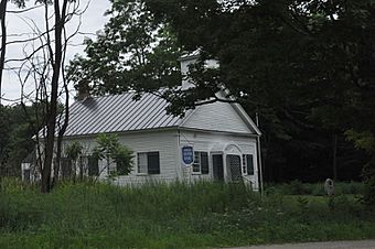
The DAR chapterhouse, a former schoolhouse
|
|
| Lua error in Module:Location_map at line 420: attempt to index field 'wikibase' (a nil value). | |
| Location | US 5 and Oxbow St., Newbury, Vermont |
|---|---|
| Area | 20 acres (8.1 ha) |
| Architectural style | Greek Revival, Federal, Cape Cod |
| NRHP reference No. | 83003211 |
| Added to NRHP | July 28, 1983 |
The Bayley Historic District is a special area in Newbury (town), Vermont. It has a group of old buildings. Many of these buildings are connected to the important Bayley family. This district includes some of the oldest buildings in Newbury. It is also where Jacob Bayley, the town's founder, first settled and later passed away.
The district is located along Oxbow Road. This road is west of United States Route 5 and north of Newbury's main village. This historic area was added to the National Register of Historic Places in 1983. This means it is recognized as an important place in American history.
Contents
What is the Bayley Historic District?
The town of Newbury was officially started in 1763. It was the first European settlement north of Charlestown, New Hampshire. This settlement was along the Connecticut River. Jacob Bayley was one of the people who helped found Newbury. He became a well-known general in the local army. He also helped create the Bayley Hazen Military Road. This road was important during the American Revolutionary War.
The Bayley Family and Their Homes
Jacob Bayley settled near a U-shaped bend in the Connecticut River. This bend is called an "oxbow" because it looks like the part of a yoke that goes around an ox's neck. The land here is very flat and good for farming. Jacob Bayley's original house is no longer standing. However, his son's house still exists. It was built around 1785 on the north side of Oxbow Road. Jacob Bayley himself passed away in this house in 1815.
Exploring the District's Location
The Bayley Historic District is about one mile north of Newbury's main village center. It is where US 5 changes direction from north-south to northeast. At this point, Oxbow Road goes west, forming a three-way intersection. The district continues west to another three-way intersection. Here, Oxbow Road turns south, and Romance Lane goes further west.
Buildings and Architecture
The district includes twelve houses. Most of these homes were built in the 1800s. There is also a schoolhouse in the district. In 1912, a local group called the Daughters of the American Revolution bought the schoolhouse. This group works to preserve American history.
Many of the houses show building styles from the mid to late 1800s. Some homes, like the Bayley house, still look like they did in the early 1800s. This style is called "Federal" architecture. The Augustine/Kelley House is a great example of "Italianate" architecture. It is located near the corner of Romance Lane and Oxbow Road.

