Beatrice Islets facts for kids
| Geography | |
|---|---|
| Location | Nepean Bay |
| Coordinates | 35°38′26″S 137°40′55″E / 35.64057°S 137.68208°E |
| Area | 10 ha (25 acres) |
| Highest elevation | 0 m (0 ft) |
| Administration | |
|
Australia
|
|
| Demographics | |
| Population | 0 |
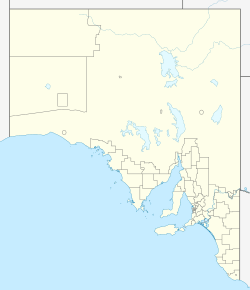
The Beatrice Islets are two small islands in South Australia. You can find them in Nepean Bay, which is on the north coast of Kangaroo Island. They are about 4 kilometers (2.5 miles) east of Kingscote. These islets and the sandy areas around them are very important homes for many birds. The islets have been a protected area since 1909. Since 1972, they have been part of the Beatrice Islet Conservation Park. Sadly, in the 1960s or 1970s, the islets were damaged when people tried to remove a plant called South African boxthorn.
Contents
What are the Beatrice Islets?
The Beatrice Islets are two small islands in Nepean Bay. They are about 4 kilometers (2.5 miles) east of Kingscote on Kangaroo Island. The islets, along with Busby Islet, are high spots on a long sandbank called 'The Spit'. This sandbank appears when the tide is low. 'The Spit' stretches about 5 nautical miles (9.3 km) from Cape Rouge, north of Kingscote. The two islets are about 1.25 kilometers (0.78 miles) apart and line up north to south.
The islets used to be sand dunes that stayed above the water. However, during the 1960s or 1970s, people tried to get rid of a plant called South African boxthorn. This plant was not native and was causing problems. This effort accidentally damaged the islets a lot. It made them easily washed away by waves and rough weather. The once stable, plant-covered islets became bare sandbanks. Later tries to make the islets stable again and help sand build up did not work. By 1987, the islets were mostly just mudflats or cockle beds that appeared at low tide.
How the Islets Formed
The sandbank called 'The Spit', and so the Beatrice Islets, formed about 7,500 years ago. This happened when the sea levels reached their current height. The islets are made of sand and small bits of rock. They are part of a larger sandbank that dries out at low tide. The water around them gets about 5 meters (16 feet) deep within 0.6 to 1.25 kilometers (0.37 to 0.78 miles) to the west.
Plants and Animals
Plants
In 1987 and again in 1996, reports said that the Beatrice Islets had no plants. This was because of the effort to remove the South African boxthorn.
Animals
Even though old reports don't list animals specifically for Beatrice Islets, many birds are seen on 'The Spit' and Busby Island nearby. It's very likely these same birds visit the Beatrice Islets too. Some of these birds include the white-bellied sea-eagle, eastern curlew, and fairy tern. You might also see little egrets, different kinds of cormorants, and Australian pelicans. Other birds like the Australian white ibis, grey plover, and various sandpipers are also common. These islets are important resting and feeding spots for many shorebirds.
History of the Islets
European Discovery
The Beatrice Islets were probably named after a ship called HMS Beatrice. This ship explored the coast of South Australia in the 1870s. Before 1919, people even mined guano (bird droppings used as fertilizer) from these islets. They had a special permit from the South Australian Government to do this.
Protecting the Islets
The Beatrice Islets first became a protected area on May 13, 1909. This was under a law called the Birds Protection Act 1900. Later, they were named a fauna reserve in 1964 to protect wildlife. In 1967, they were again set aside to protect wildlife habitats. Finally, in 1972, they became a conservation park under the National Parks and Wildlife Act 1972. As of 2012, the waters around the islets are also protected as part of the Encounter Marine Park.
The Beatrice Islets are also part of a bigger area that includes 'The Spit' and Busby Islet. This whole area in Nepean Bay is listed as an important wetland in Australia. This means it's recognized for its special natural value.
 | Stephanie Wilson |
 | Charles Bolden |
 | Ronald McNair |
 | Frederick D. Gregory |


