Beaver, Alaska facts for kids
Quick facts for kids
Beaver
Ts'aahudaaneekk'onh Denh
|
|
|---|---|

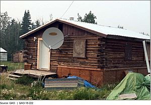
A house in Beaver, February 2016
|
|

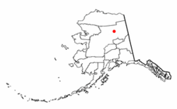
Location of Beaver, Alaska
|
|
| Country | United States |
| State | Alaska |
| Census Area | Yukon-Koyukuk |
| Area | |
| • Total | 21.04 sq mi (54.51 km2) |
| • Land | 20.52 sq mi (53.14 km2) |
| • Water | 0.53 sq mi (1.36 km2) |
| Population
(2020)
|
|
| • Total | 48 |
| • Density | 2.34/sq mi (0.90/km2) |
| Time zone | UTC-9 (Alaska (AKST)) |
| • Summer (DST) | UTC-8 (AKDT) |
| ZIP code |
99724
|
| Area code(s) | 907 |
| FIPS code | 02-05750 |
Beaver is a small community in Alaska, United States. Its name in the Koyukon is Ts'aahudaaneekk'onh Denh. It is known as a census-designated place (CDP). This means it's an area identified by the government for gathering population data. In 2010, 84 people lived there. By 2020, the population had changed to 48 people.
Contents
Where is Beaver located?
Beaver is found in the Yukon-Koyukuk Census Area in Alaska. It is located at 66°21′35″N 147°23′51″W / 66.359719°N 147.397438°W.
The community covers a total area of about 21.6 square miles (56 square kilometers). Most of this area, about 20.5 square miles (53 square kilometers), is land. The rest, about 1.1 square miles (2.8 square kilometers), is water.
How many people live in Beaver?
Beaver first appeared in the U.S. Census in 1930. Back then, 103 people lived there. Over the years, the population has changed. It was 84 people in both 2000 and 2010. The most recent count in 2020 showed 48 residents.
Beaver's population in 2020
In 2020, there were 48 people living in Beaver. These people lived in 41 households. The community had 57 housing units in total. This means there were about 2.34 people per square mile.
Most of the people in Beaver, about 95.83%, were Native Americans. About 2.08% were White. Another 2.08% were Hispanic or Latino.
The average income for a household was $36,964 per year. For families, the average income was $46,250. These amounts were lower than the average income for all of Alaska, which was $88,121. About 26.2% of the people in Beaver lived in poverty. This included 61.1% of children under 18.
Most adults in Beaver had jobs, with an employment rate of 72.7%. Many workers, about 70.8%, worked for the government. About 22.9% worked for private companies. Another 6.3% worked for private non-profit groups. When it came to getting to work, all workers aged 16 and older walked. Their average walk to work was about 5.6 minutes.
Education in Beaver
The Yukon Flats School District is responsible for schools in Beaver. They operate the Cruikshank School, which serves the community.
See also

- In Spanish: Beaver (Alaska) for kids
 | Tommie Smith |
 | Simone Manuel |
 | Shani Davis |
 | Simone Biles |
 | Alice Coachman |


