
Beaver Gut Ditch facts for kids
Quick facts for kids Beaver Gut Ditch |
|
|---|---|


Location of Beaver Gut Ditch mouth
|
|
| Other name(s) | Tributary to St. Jones River |
| Country | United States |
| State | Delaware |
| County | Kent |
| Physical characteristics | |
| Main source | Thorndyk Branch divide Pond about 0.25 miles west of Magnolia, Delaware 20 ft (6.1 m) 39°04′26″N 075°29′03″W / 39.07389°N 75.48417°W |
| River mouth | St. Jones River Florence, Delaware 0 ft (0 m) 39°05′09″N 075°29′03″W / 39.08583°N 75.48417°W |
| Length | 1.36 mi (2.19 km) |
| Basin features | |
| Progression | northeast |
| River system | St. Jones River |
| Basin size | 1.79 square miles (4.6 km2) |
| Tributaries |
|
| Bridges | South State Street, Ponderosa Drive |
Beaver Gut Ditch is a small waterway, or tributary, located in Kent County, Delaware. It flows for about 1.36 miles (2.19 km) and eventually joins the St. Jones River. Think of it as a small stream that feeds into a larger river.
Where Beaver Gut Ditch Flows
Beaver Gut Ditch begins in a pond near a place called Thorndyk Branch. This starting point is about 0.25 miles west of a town called Magnolia, Delaware.
From there, the ditch flows towards the northeast. Its journey ends when it meets the St. Jones River in a spot known as Florence, Delaware.
About the Beaver Gut Ditch Area
The area that drains water into Beaver Gut Ditch is called its watershed. This watershed covers about 1.79 square miles (4.64 square kilometers).
Each year, this area gets about 44.8 inches (114 cm) of rain. About 5.1% of the land in this watershed is covered by forests.
Images for kids
-
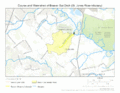
This map shows where Beaver Gut Ditch flows and the area it drains.
.gif)
