
Beaver Hills Historic District facts for kids
Quick facts for kids |
|
|
Beaver Hills Historic District
|
|
 |
|

Location in Connecticut

Location in the United States
|
|
| Location | Roughly bounded by Crescent St., Goffe Terr., and Boulevard, New Haven, Connecticut |
|---|---|
| Area | 97 acres (39 ha) |
| Built | 1870 |
| Architect | Beaver Hills Co.; Et al. |
| Architectural style | Colonial Revival, Bungalow/Craftsman, Tudor Revival |
| NRHP reference No. | 86002108 |
| Added to NRHP | July 31, 1986 |
The Beaver Hills Historic District is a special area in New Haven, Connecticut. It's like a time capsule of homes built between 1908 and 1936. This district covers about 97 acres. It was added to the National Register of Historic Places in 1986. This means it's recognized as an important historical place. In 1986, it had 235 buildings that helped tell its story.
Contents
What Makes Beaver Hills Special?
The Beaver Hills Historic District is a great example of an early 1900s suburb. Most homes here are single-family houses. They show off popular styles from that time. You can see homes in the Colonial Revival style, Tudor Revival style, and Bungalow styles. Other styles like Queen Anne and Spanish Colonial Revival are also found.
Cool Homes and Buildings
Some of the notable buildings in the district include:
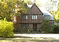
- The Pitkin House, built in 1931, is a Tudor Revival style home. It's a two-and-a-half-story house with a gable roof. It has a unique stucco and half-timbered outside.

- The Alan Krevit House, built in 1936, is a two-and-a-half-story Colonial Revival style home. It's a frame house with a gable roof.

You can also find brick gateway pillars at the south end of the district. These are at the corners of Goffe Terrace with Norton Parkway and Ellsworth Avenue. The pillars have cool tile pictures of beavers on them. The Beaver Hills Company built them in 1908. They marked the entrance to the neighborhood.
A Look Back in Time: History of Beaver Hills
The name "Beaver Hills" comes from a long time ago. Many beavers used to live in the ponds in this area. Before the 1900s, this land was mostly farmland.
How the Neighborhood Grew
In 1906, a farmer named George Mead passed away. His family decided to divide his farm into smaller pieces for homes. They also bought parts of nearby farms. They created the Beaver Hills Development Company. This company planned the streets and built some houses. They also sold lots to other people.
The company made rules about how big and nice the houses had to be. This helped make sure the neighborhood looked good. They also built special gates at the southern entrances. This made the neighborhood feel exclusive and special. The company even built a clubhouse for the community. They continued to develop the area until 1938. That's when they sold their last land lots. Another nearby farm, the Farnham farm, was developed in a similar way starting in the 1920s. It had almost the same building rules.
Gallery
-
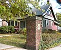
389 Norton Parkway at Goffe Terrace (1908), gate cottage with pier and tile beaver plaque.
-
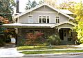
460 Ellsworth Ave (1912) with porte-cochère.
-
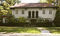
Italian villa, 475 Ellsworth Ave (1915), R. W. Foote.
-
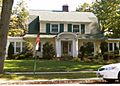
Dutch Colonial, 517 Ellsworth Ave. (1920), Brown and VonBeren.
-
636 Ellsworth Ave (1938), Lewis Bowman, Bronxville.


