Beinn-y-Phott facts for kids
Quick facts for kids Beinn-y-Phott |
|
|---|---|

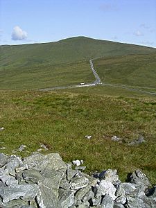
seen from the top of Cairn Gerjoil looking across Windy Corner
|
|
| Highest point | |
| Elevation | 1,791 ft (546 m) |
| Prominence | 443 ft (135 m) |
| Naming | |
| English translation | point of the pot |
| Geography | |
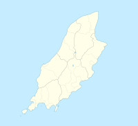
| Location | Isle of Man |
| OS grid | SC381860 |
Beinn-y-Phott is a mountain peak on the beautiful Isle of Man. It stands 546 meters (about 1,791 feet) tall. Its name comes from the Manx Gaelic words meaning "turf summit." People sometimes call it 'penny pot'. This peak is an important landmark on the island.
Contents
Exploring Beinn-y-Phott
Beinn-y-Phott is a well-known peak on the Isle of Man. It offers great views of the surrounding area. The mountain is a popular spot for walkers and nature lovers.
Where is Beinn-y-Phott?
This peak is located on the Isle of Man, an island in the Irish Sea. It is about 2 kilometers (1.2 miles) southwest of Snaefell, which is the highest mountain on the island. Beinn-y-Phott is found at the southern end of the Kirk Lezayre parish.
Nature on the Peak
Beinn-y-Phott is covered in wide, open moorland. This type of land is often found in hilly areas. It is home to many interesting plants. You can find different types of heather growing here. There are also peat mosses and sedges. Scientists have studied the plants on Beinn-y-Phott. They learned about how the vegetation has changed over thousands of years.
Beinn-y-Phott and the TT Races
Beinn-y-Phott is close to a very famous road. This road is part of the TT races. The TT races are a well-known motorcycle event. The Mountain Course, used for these races, goes around the peak. The area near Beinn-y-Phott is called Brandywell. This spot is a famous part of the race course.


