Beinn Bhàn (Applecross) facts for kids
Quick facts for kids Beinn Bhàn |
|
|---|---|

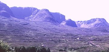
The corries on the eastern side of Beinn Bhàn
|
|
| Highest point | |
| Elevation | 896 m (2,940 ft) |
| Prominence | 851 m (2,792 ft) Ranked 20th in British Isles |
| Parent peak | Sgurr Mor |
| Listing | Marilyn, Corbett |
| Naming | |
| English translation | white mountain |
| Language of name | Gaelic |
| Geography | |
|
Lua error in Module:Location_map at line 420: attempt to index field 'wikibase' (a nil value).
|
|
| Parent range | Applecross peninsula |
| OS grid | NG804450 |
| Topo map | OS Landranger 24 |
Beinn Bhàn is a cool mountain located in the Highlands of Scotland. It sits on the Applecross peninsula, right on the north side of Loch Kishorn. Its name, "Beinn Bhàn," means "white mountain" in Gaelic. It's a popular spot for hikers and climbers!
Discover Beinn Bhàn
Beinn Bhàn stands tall at 896 meters (about 2,940 feet) above sea level. It's known as both a Marilyn and a Corbett, which are special categories for mountains in the British Isles based on their height and how much they stand out from the land around them.
What Makes Beinn Bhàn Special?
The most amazing parts of Beinn Bhàn are the rocky areas called corries on its eastern side. A corrie is like a giant, natural armchair shape carved into the mountain by glaciers long ago. You can see these corries really well from the nearby A896 road.
One of the most famous corries is Coire na Poite. It looks like a big bowl almost completely surrounded by steep cliffs. These cliffs are perfect for climbing and even ice climbing in winter! At the bottom of the corries, you'll find two small lochans, which are tiny lakes. The very top of Beinn Bhàn is right above these corries.
Routes to the Top
There are several ways to reach the summit of Beinn Bhàn. Some routes involve scrambling, which is like a mix of hiking and easy rock climbing where you use your hands for balance. These routes follow the ridges between the corries.
If you're not a fan of heights, there's an easier way up! You can climb the grassy southwest ridge of the mountain. This path starts near where the famous Bealach na Bà road leaves the A896. It's about 4 kilometers (2.5 miles) long.
Another route, which is a bit longer but involves less climbing uphill, starts from the very top of the Bealach na Bà. This road is already over 600 meters (about 1,970 feet) above sea level! From there, you walk around the northern part of another peak called Sgurr a'Chaorachain to reach the bealach (a mountain pass) that separates it from Beinn Bhàn.
Many people like to climb Beinn Bhàn and Sgurr a'Chaorachain together on the same trip, making for a fantastic day out in the Scottish Highlands!
 | Frances Mary Albrier |
 | Whitney Young |
 | Muhammad Ali |

