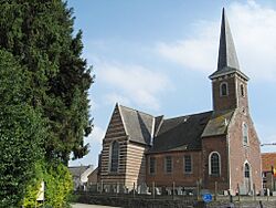
Bekkevoort facts for kids
Quick facts for kids
Bekkevoort
|
|||
|---|---|---|---|
 |
|||
|
|||
| Country | Belgium | ||
| Community | Flemish Community | ||
| Region | Flemish Region | ||
| Province | Flemish Brabant | ||
| Arrondissement | Leuven | ||
| Area | |||
| • Total | 37.17 km2 (14.35 sq mi) | ||
| Population
(2018-01-01)Lua error in Module:Wd at line 1575: attempt to index field 'wikibase' (a nil value).
|
|||
| • Total | Lua error in Module:Wd at line 1,575: attempt to index field 'wikibase' (a nil value). | ||
| Postal codes |
3460, 3461
|
||
| Area codes | 013, 016 | ||
| Website | www.bekkevoort.be | ||
Bekkevoort is a town, also called a municipality, located in the country of Belgium. It's part of the Flemish Brabant province.
Bekkevoort isn't just one single place; it includes the towns of Assent, Bekkevoort itself, and Molenbeek-Wersbeek. As of January 1, 2006, about 5,826 people lived there. The total area of Bekkevoort is about 37.17 square kilometers. This means there are about 157 people living in each square kilometer.
Contents
The Story Behind the Name
The name "Bekkevoort" has an interesting history! It comes from an old Germanic name, "Baco," and the word "voorde."
What Does "Voorde" Mean?
"Voorde" means a shallow place in a river or stream where you can easily cross. Think of it like a natural bridge over water. So, "Bekkevoort" roughly means "Baco's crossing point."
Where Was the Crossing?
This special crossing point was once the most important part of the town. Today, you can find this historic spot along a road called Steenberg. This road connects Bekkevoort to other towns like Zichem and Scherpenheuvel.
Life in Bekkevoort
Bekkevoort is a lively community with its own local government.
Who Leads the Town?
The mayor of Bekkevoort is Hans Vandenberg. He is part of a political group called CD&V, which works with another group called Ons Dorp to lead the town.
Quick Facts
- Location: Leuven area
- Postal Codes: 3460, 3461
- Telephone Area Codes: 013, 016
- Official Website: www.bekkevoort.be
See also
 In Spanish: Bekkevoort para niños
 | DeHart Hubbard |
 | Wilma Rudolph |
 | Jesse Owens |
 | Jackie Joyner-Kersee |
 | Major Taylor |


