
Belas Knap facts for kids

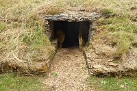
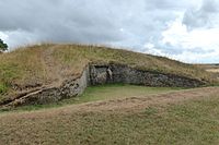
The northern end of the site, showing the intricate false entrance.
|
|

Location in Gloucestershire
|
|
| Location | Winchcombe, Gloucestershire. |
|---|---|
| Coordinates | 51°55′38″N 1°58′15″W / 51.92722°N 1.97083°W |
| Type | Chambered long barrow |
| Part of | Severn-Cotswold tombs |
| History | |
| Periods | Neolithic |
| Site notes | |
| Excavation dates | 1863-1865 and 1928–30 |
| Ownership | English Heritage |
| Management | Gloucestershire County Council |
| Official name | Belas Knap |
| Designated | 30 August 1922 |
| Reference no. | 1008199 |
Belas Knap is a very old burial mound from the Neolithic period, also known as the New Stone Age. It is located on Cleeve Hill, near Cheltenham and Winchcombe, in Gloucestershire, England. This special site is looked after by English Heritage and managed by Gloucestershire County Council.
The name "Belas" might come from a Latin word meaning 'beautiful'. This could describe the hill or its amazing views. "Knap" comes from an Old English word for the top or summit of a hill. Belas Knap is a type of ancient monument called a Cotswold Severn Cairn. These cairns are shaped like a trapezoid, which is a bit like a stretched-out rectangle with sloped sides. You can find similar mounds scattered along the River Severn. Belas Knap is considered an excellent example of these Cotswold-Severn tombs.
Contents
What is Belas Knap?
Belas Knap is a chambered long barrow. This means it's a long, raised mound of earth and stones that contains burial chambers. People built it around 3000 BC. Over many years, people were buried here. After a period of use, the burial chambers were carefully blocked up.
How Big is Belas Knap?
This ancient mound is quite large!
- It is about 54 meters (178 feet) long.
- It is about 18 meters (60 feet) wide.
- It stands nearly 4 meters (14 feet) high.
What Does Belas Knap Look Like?
Belas Knap has some interesting features.
The False Entrance
When you first see Belas Knap, you might notice what looks like a main entrance. It has fancy dry-stone walls and big limestone blocks. However, this is actually a false entrance.
Why would they build a fake door?
- It might have been to stop robbers from finding the real burial chambers.
- Another idea is that it was a 'spirit door'. This was a special place for the spirits of the dead to come and go. It also allowed their families to leave offerings for them.
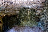
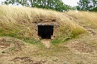
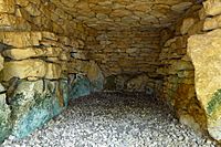
The Real Burial Chambers
The actual burial chambers are hidden. You can find them along the long east and west sides of the mound, and at its southern end.
- There are four burial chambers in total.
- Two chambers are on opposite sides near the middle.
- One chamber is at the south-east corner.
- The last chamber is at the very south end.
These chambers were made from upright stone slabs. They were connected by dry-stone walls and originally had special arched roofs called corbelled roofs.
Discoveries at Belas Knap
People have explored Belas Knap several times to learn more about it.
Early Excavations (1863-1865)
During the first explorations, archaeologists found some interesting things blocking the false entrance.
- They found the bones of five children, aged from 6 months to 8 years old.
- They also found the skull of a young adult man.
- Animal bones (from horses and pigs), pottery pieces, and flint blades were also discovered.
The passages leading to the real burial chambers were roughly blocked with stones and clay. Much of the stone work, including the lintels (the top parts of doorways) and dry-stone walls, was rebuilt during these early excavations.
Later Work (1928-1931)
After more work in the late 1920s and early 1930s, the walls were made secure. Three of the chambers were covered, and the shape of the mound was restored to how it might have looked long ago.
More Finds (1963)
In 1963, even more discoveries were made!
- The remains of 38 human skeletons were found.
- More animal bones, flint tools, and pottery from the end of the Neolithic period (around 2000 BC) were also uncovered.
It's important to remember that these burials happened over a very long time. It's possible that none of these specific burials were from when the mound was first built.
Visiting Belas Knap
You can visit Belas Knap by taking one of two paths.
- The most common path starts from the steep Charlton Abbots road, south of Winchcombe. There's a small parking area. The path goes up through trees. It's a steep climb at first, but you get great views of Winchcombe. This walk takes about 10 minutes.
- The other path starts from a "no through road" that goes up to Corndean Hall. The last part of this route is on an unpaved track where cars cannot go. This path avoids the steep climb and approaches the site from the west.
Location Details
The mound is located just below the summit of Cleeve Hill.
Gallery
-
Chamber C
-
Interior of Chamber C
-
Chamber D
-
Interior of Chamber B
-
False Portal Entrance


See also
 In Spanish: Belas Knap para niños
