Belleview, Kentucky facts for kids
Quick facts for kids
Belleview, Kentucky
|
|
|---|---|
|
Census-designated place (CDP)
|
|

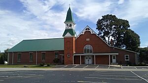
Belleview Baptist Church
|
|

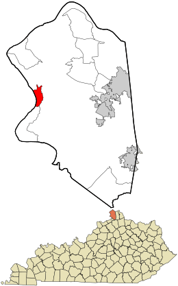
Location within Boone County and the state of Kentucky
|
|
| Country | United States |
| State | Kentucky |
| County | Boone |
| Area | |
| • Total | 1.86 sq mi (4.82 km2) |
| • Land | 1.36 sq mi (3.52 km2) |
| • Water | 0.50 sq mi (1.30 km2) |
| Elevation | 495 ft (151 m) |
| Population
(2020)
|
|
| • Total | 308 |
| • Density | 226.47/sq mi (87.42/km2) |
| Time zone | UTC-5 (Eastern (EST)) |
| • Summer (DST) | UTC-4 (EDT) |
| Area code(s) | 859 |
| FIPS code | 21-05428 |
| GNIS feature ID | 2629575 |
Belleview is a small place in Boone County, Kentucky, in the United States. It is called an "unincorporated community" because it doesn't have its own local government like a city does. It's also a "census-designated place" (CDP), which means the government counts its population for official records.
In 2020, about 308 people lived in Belleview. This number was a little smaller than in 2010, when 343 people lived there.
Contents
Where is Belleview Located?
Belleview is in the western part of Boone County. It sits right along the Ohio River. This river forms the border between Kentucky and Indiana.
The community is about 24 miles (39 km) southwest of Cincinnati, a big city. A road called Kentucky Route 18 (also known as Burlington Pike) goes east from Belleview. It leads to Burlington, which is the main town of Boone County, about 7 miles (11 km) away. The road also goes to Florence, which is about 13 miles (21 km) from Belleview.
Land and Water Area
Belleview covers a total area of about 1.86 square miles (4.8 square kilometers). Most of this area is land, about 1.36 square miles (3.5 square kilometers). The rest, about 0.50 square miles (1.3 square kilometers), is water. This water part is mainly the Ohio River.
Historic Places in Belleview
Belleview is home to several buildings that are important for their history. These places are listed on the U.S. National Register of Historic Places. This means they are protected because they tell us about the past.
Some of these historic spots include:
- Belleview Baptist Church
- Belleview Post Office
- Clore House
- Jonas Clore House
- Flick House
- James Rogers House
How Many People Live Here?
The number of people living in Belleview has changed over time. The United States Census Bureau counts the population every ten years.
| Historical population | |||
|---|---|---|---|
| Census | Pop. | %± | |
| 2010 | 343 | — | |
| 2020 | 308 | −10.2% | |
| U.S. Decennial Census | |||
See also
 In Spanish: Belleview (Kentucky) para niños

