
Bellows Falls Neighborhood Historic District facts for kids
|
Bellows Falls Neighborhood Historic District
|
|

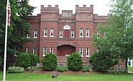
Old YMCA, Bellows Falls
|
|

Location in Vermont

Location in the United States
|
|
| Location | Atkinson, Westminster, School, Hapgood Sts, Hapgood Pl., Burt St., Henry St., South St., Hadley St., Temple Pl., Bellows Falls, Vermont |
|---|---|
| Area | 42.3 acres (17.1 ha) (original) 8.8 acres (3.6 ha) (increase) |
| Built by | Multiple |
| Architect | Buckman (20 South St.) |
| Architectural style | Federal, Greek Revival |
| NRHP reference No. | 01001477 (original) 07000403 (increase) |
Quick facts for kids Significant dates |
|
| Added to NRHP | January 17, 2002 |
| Boundary increase | May 4, 2007 |
The Bellows Falls Neighborhood Historic District is a special part of Bellows Falls, Vermont. It's a residential area, meaning people live there. You can find it just south of the main downtown area. This district has one of the largest collections of well-preserved 19th-century homes in southern Vermont. It was first recognized as a historic place in 2002. Later, in 2007, the district was made even larger to include more historic buildings.
Contents
What is Bellows Falls?
Bellows Falls is a village located in southeastern Vermont. It's part of the larger town called Rockingham. The village sits right on the west bank of the Connecticut River.
A Hub for Travel
Bellows Falls became very important for travel. In 1785, the first bridge across the Connecticut River was built here. This made the village a key spot for moving goods and people. Over the 1800s, it became a major center. Water routes, roads, and railroads all came together in Bellows Falls.
Power from the River
The Bellows Falls Canal also played a big role. This canal used the river's water power. It helped many different industries grow in the village. The downtown area developed right next to the canal. The neighborhoods where people lived grew west and south of the downtown.
About the Historic District
When the historic district was first created in 2002, it covered about 42 acres. Its northern edge was School Street. Westminster Street was its eastern border. Atkinson Street, which is also United States Route 5, formed its western side. The district also stretched a bit west of Atkinson on Burt Street and Hapgood Place.
Growing the District
In 2007, the district got bigger. About 9 more acres were added to the southwest. This expansion included areas south of Burt Street. It reached as far as Pine and Center Streets. It also extended to Old Terrace in the southeast.
Historic Homes and Buildings
This neighborhood has some of the best examples of homes built before World War II in southern Vermont. Most of the houses are made of wood. They typically have one to three living units inside.
Architectural Styles
Most of the buildings in this area were constructed between 1850 and 1920. This was a time when Bellows Falls was doing very well economically. The homes show many different architectural styles from that period. Some of the oldest buildings in the district date back to the late 1700s.
Other Important Buildings
Besides homes, the district also includes several important public buildings. These are two schools and two churches. There are also two fraternal meeting houses. You can find a library and a funeral home here too. More than 90% of the buildings in the district were built before 1950. This is a very high number for a historic area of this size.
- Bellows Falls Neighborhood Historic District
-
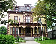
The Bellows Falls Masonic Temple was built around 1870. It used to be the Wyman & Almira Flint House. It's in the Second Empire style.
-
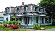
A Victorian house at 6 Temple Street.
-
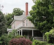
The William A. Hall House was built in 1890–92. It's in the Colonial Revival style. Today, it's known as the Readmore Inn.
-
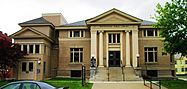
The Rockingham Free Public Library was built in 1909. It's a Carnegie library, funded by Andrew Carnegie.
-
This building used to be the armory for Company E of the First Infantry of the Vermont National Guard. It was built in 1915. Now, it provides housing for people with lower incomes.


