Ben Mor Coigach facts for kids
Quick facts for kids Ben Mor Coigach |
|
|---|---|
| Beinn Mhòr na Còigich | |

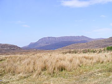
Ben Mor Coigach from the south-east
|
|
| Highest point | |
| Elevation | 743 m (2,438 ft) |
| Prominence | 657 m (2,156 ft) Ranked 81st in British Isles |
| Listing | Marilyn, Graham |
| Geography | |
| Location | Coigach, Ross and Cromarty, Scotland |
| Parent range | Northwest Highlands |
| OS grid | NC094042 |
| Topo map | OS Landranger 15 |
Ben Mor Coigach (which means Big Mountain of Coigach in Scottish Gaelic) is a cool, flat-topped mountain in the very north-west of Scotland. It stands tall over the Coigach area, which is a peninsula. This mountain is in the county of Ross and Cromarty, about 10 kilometres (6 miles) north-west of the town of Ullapool.
Ben Mor Coigach is 743 metres (2,438 feet) high. Because it's right by the coast and rises so much from the land around it, it offers amazing views. It's also a special place because it's a nature reserve looked after by the Scottish Wildlife Trust.
Contents
Climbing Ben Mor Coigach
If you like hiking, Ben Mor Coigach offers some exciting routes to the top. You can start your climb from two main places: Bleughasary, which is to the south-east, or Culnacraig, to the south-west. Both places have parking spots for cars.
Routes from Bleughasary
From Bleughasary, you can follow a track that leads towards Loch Eadar dha Bheinn. This track isn't always shown on maps, but it's there. Once you reach the loch, you'll go past the water flowing out on the east side. Then, you head up onto the mountain's east ridge.
This path takes you over a part called Speicin Coinnich. It might look a bit steep from below, but it's not as tricky as it seems. After this, you'll reach a large, flat area at the very top of the mountain.
Routes from Culnacraig
Another good starting point is Culnacraig. It's a bit further to drive to, but it offers a different adventure. From here, you follow a long ridge that goes towards a peak called Sgurr an Fhidhleir, also known as "the Fiddler."
You can choose to climb to the top of Sgurr an Fhidhleir, or you can go around its south side. After that, you'll make your final climb to the summit of Ben Mor Coigach from the north-east. There are other ways to go, but they can be very steep and rocky. Some people also like to explore other peaks nearby, which form a horseshoe shape around the main mountain.
The Famous Postman's Path
Some hikers enjoy a longer adventure by combining a climb up Ben Mor Coigach with a walk along the "Postman's Path." This path runs along the coast from Achiltibuie to Strathcanaird. It's called the Postman's Path because old postmen used it to deliver mail before roads connected the villages.
What to Expect on the Path
Maps and signs suggest this part of the journey is about six miles long. However, the path is known for being quite challenging. Even fit hikers might take four hours or more to complete it, depending on how fast they walk and what the weather is like.
- No Clear Path: For much of the route, there isn't a clear path. You'll find some cairns (piles of stones) and posts with arrows, but they can be hard to follow. It's easy to get off track.
- Climbing Needed: In several spots, you'll need to do some scrambling, which means using your hands to climb over rocks. Some of these parts are close to sea cliffs, so you need to be careful.
- River Crossings: You'll also need to cross several fast-flowing streams. There are no bridges, so crossing them can be difficult, especially after heavy rain when the water is high.
- Muddy Areas: The path also goes through boggy, muddy areas, which can make walking even harder.
Even though it's not very high up, the Postman's Path feels like a true mountain adventure because of all these challenges. It's important to be well-prepared and careful if you decide to explore this historic route.
 | Lonnie Johnson |
 | Granville Woods |
 | Lewis Howard Latimer |
 | James West |

