
Ben of Howth facts for kids
Quick facts for kids Ben of Howth |
|
|---|---|
| Beann Éadair | |

Ben of Howth Radio Mast
|
|
| Highest point | |
| Elevation | 171 m (561 ft) |
| Prominence | 167 m (548 ft) |
| Listing | Marilyn |
| Geography | |
|
Lua error in Module:Location_map at line 420: attempt to index field 'wikibase' (a nil value).
|
|
| Location | Dublin, Ireland |
| OSI/OSNI grid | O285376 |
| Topo map | OSi Discovery 50 |
The Ben of Howth (pronounced HOHTH) is a lovely hilly area found on Howth Head in Dublin, Ireland. It sits right next to Black Linn, which is the highest spot on the peninsula, reaching 171 meters high. The Ben of Howth is known as a "Marilyn." This is a special name for hills in Britain and Ireland that are at least 150 meters tall and stand out from the land around them by at least 150 meters.
Exploring Ben of Howth
The Ben of Howth is located about 1.5 kilometers (or about a mile) south of Howth village. If you want to visit, the closest road is Windgate Road. From there, you can follow a path that goes west, passing by the Green Hallows quarry.
Nearby Hills
Two other interesting peaks on Howth Head are close to the Ben of Howth. One is Shelmartin or Shielmartin, which is about 1 kilometer (half a mile) to the west. The other is Dun Hill, located about 0.5 kilometers (a quarter of a mile) to the north west.
Images for kids
-
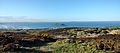
North-facing view
-
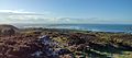
Northwest facing view
-
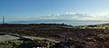
Ben of Howth, southwest facing view
-
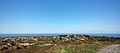
Ben of Howth, east view


